
Following the spots: What 15 years of data reveal about jaguars and connectivity in the borderlands
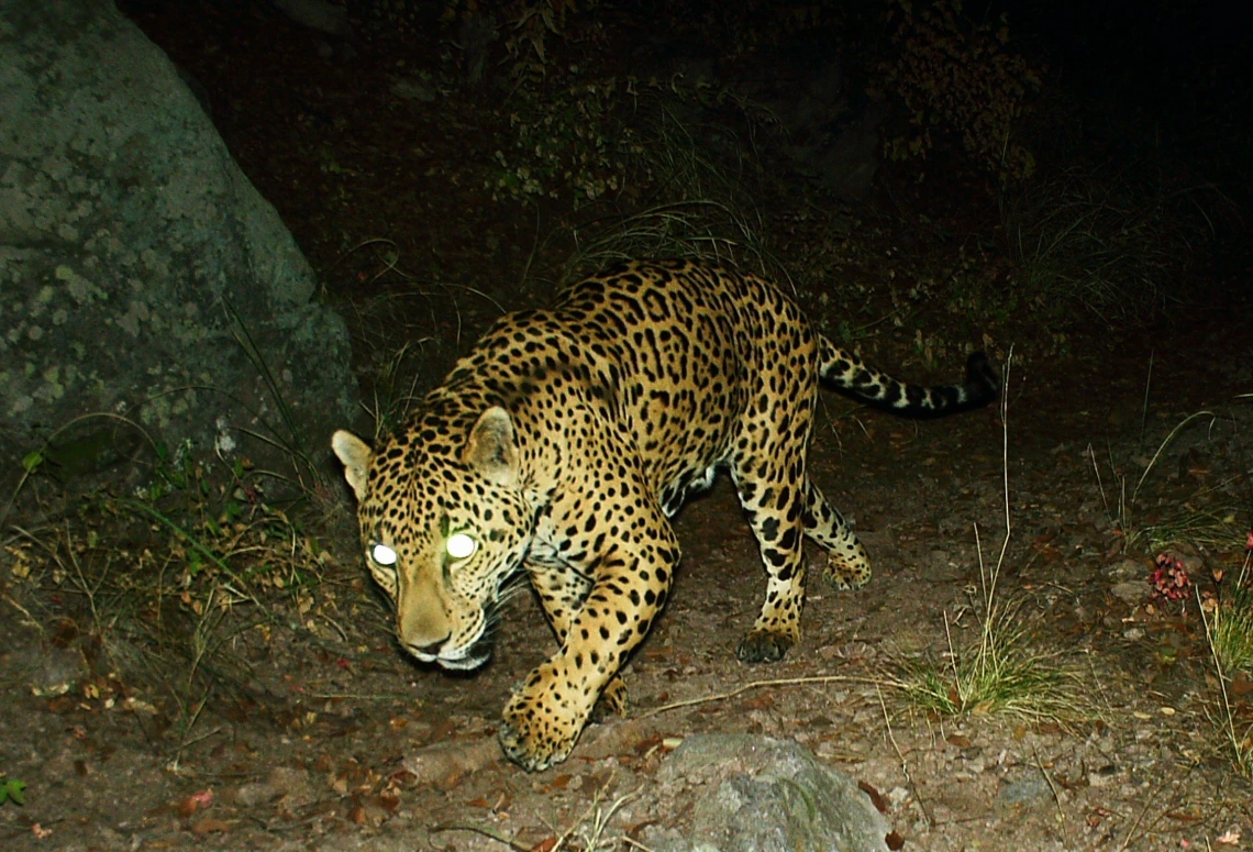
A jaguar at night, captured by wildlife cameras monitored by the Wild Cat Research and Conservation Center in 2021.
Since August 2025, seven new jaguar detections have been confirmed in southern Arizona. It’s a rewarding moment for University of Arizona conservation scientists who have spent the last 15 years continuously tracking these elusive apex predators through the U of A Wild Cat Research and Conservation Center, also known as the Wild Cat Center.
For Susan Malusa, Wild Cat Center Director and a research specialist in the School of Natural Resources and the Environment, those detections weren’t just wildlife sightings, but data points in a long scientific record showing how the ecosystem is still connected and alive.
“These detections are a powerful reminder that jaguars are still moving through corridors that connect the borderlands,” Malusa explained.
While these recent detections offer hope, jaguars have a long and storied history in the region, one that stretches back well before modern conservation efforts.
A historic range
Before widespread hunting and habitat loss in the early 20th century, jaguars (Panthera onca) roamed much of Arizona, from the lowland deserts in southern Arizona to the high-elevation conifer forests in the White Mountains and, occasionally, as far north as the Grand Canyon.
Research led by Melanie Culver, co-coordinator of the Wild Cat Center and a member of the U of A Cooperative Fish and Wildlife Research Unit, confirmed more than 80 verified jaguar records spanning 160 years. These records include museum specimens, field observations, historical newspaper clippings, and hunting trophies that documented jaguar sightings and captures across southern Arizona.
These historical records also provide evidence of females and sub-adults before 1920, suggesting that jaguars not only traveled through Arizona but may have bred here, with the last confirmed female recorded in 1963.
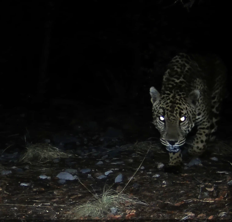
A jaguar detected at night by wildlife cameras monitored by the U of A Wild Cat Research and Conservation Center. One of 7 detections confirmed since August 2025.
Jaguars on the edge
The jaguars detected in southern Arizona represent the northernmost edge of the species’ range today. These cats endure conditions most jaguars never face, from snow in high-elevation mountains to the extreme heat of Arizona’s desert canyons.
“Edge populations matter,” Malusa said. “They’re small, but they carry traits that could help the species survive future change.”
Because edge populations exist at the limits of a species’ range, they often face unique environmental pressures that can favor adaptive traits, making them crucial to the long-term resilience of the species.
What connectivity really means
Connectivity is central to the work of the Wild Cat Center. At its core, it describes the ability of species to move freely through their habitat and maintain what scientists call genetic flow, keeping populations diverse and resilient rather than isolated and vulnerable.
When habitats become fragmented—by roads, fences, or development—these vital movements are blocked, reducing ecological resilience and making species more susceptible to environmental change.
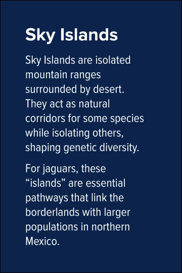
The Sky Islands region forms a critical link between Mexico’s Sierra Madre and the mountain ranges of southern Arizona. These movement corridors allow jaguars and other wildlife to traverse rugged terrain, maintain predator-prey interactions, and support ecosystem function.
“Maintaining landscape connectivity is critical, not only for jaguars but for the health of all wildlife communities,” Malusa said. “We see jaguars using these corridors, but so do deer, mountain lions, gray foxes, and even birds.”
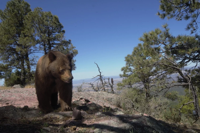
A bear roams the Sky Islands region, captured by cameras monitored by the Wild Cat Research and Conservation Center in May of 2021.
Science at work
In addition to traditional camera-trap monitoring, the Wild Cat Research and Conservation Center now incorporates environmental DNA (eDNA) sampling, a technique that detects traces of genetic material left behind in soil, water, or scat. These molecular clues can identify species even when the animals themselves remain unseen.
“eDNA gives us another way to confirm presence in places where cameras might miss activity,” Malusa explained. “It’s especially powerful in remote areas, where a single water source might hold genetic evidence of multiple species.”
This molecular approach complements the long-term visual dataset, helping researchers fill in the gaps between detections and understand how species move through rugged terrain.
Over the past 15 years, the Wild Cat Research and Conservation Center has conducted year-round monitoring, logging more than 200 camera-trap detections of jaguars and 50 ocelots. All field data are managed in SPARCd –short for Scientific Photo Analysis for Research and Conservation database – a centralized database developed by the Wild Cat Center to enable long-term wildlife data management and pattern analysis.
“Our strength is the long view,” Malusa said. “We’ve kept this project running for 15 years. That consistency allows us to see patterns, not just moments.”
Malusa is quick to clarify that the Wild Cat Research and Conservation Center isn’t a brick-and-mortar facility.
“We’re not a center with walls,” she said. “It’s really a long-term research collaboration built around data, fieldwork, and partnerships.”
Citizen science
More than 40 trained citizen scientists assist with camera checks, scat collection, data logging, and outreach. This network of volunteers allows the team to cover large, remote areas that would be impossible for a small research crew alone. Wild Cat Center volunteers hike rugged terrain, often walking miles through heat, cold, and isolation to reach cameras tucked into mountain canyons.
“These folks are out there day after day, hiking remote mountain trails, often in extreme heat or snow, just to make sure our cameras are working and our data are solid,” Malusa said. “Their dedication is what makes this project possible.”
Volunteers’ boots-on-the-ground effort helps the Wild Cat Center capture a full picture of Arizona’s wildlife and keep datasets consistent and robust.
“Citizen science lets us scale up,” Malusa said. “We can cover areas no single research team could manage on its own.”
Their work extends beyond jaguars, revealing how interconnected the region’s wildlife truly is, according to Malusa. “When we talk about jaguars, we’re really talking about the entire system,” she said. “Every camera capture tells us about the web of species that still use these landscapes.”
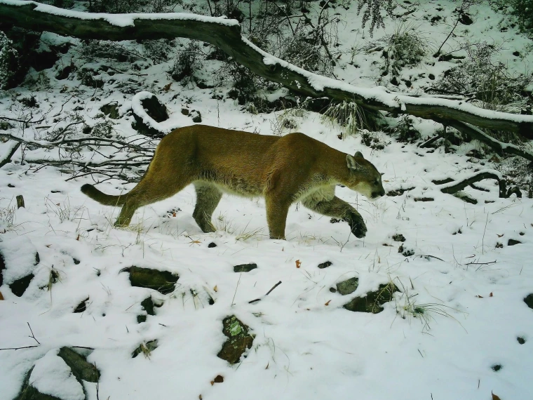
A mountain lion navigates snow in an image captured by cameras monitored and maintained by the Wild Cat Research and Conservation Center.
Data for decisions
The information collected by the Wild Cat Center informs land management, conservation planning, and connectivity modeling. The focus remains squarely on biology and understanding how animals use the landscape, not politics.
“Our work isn’t about drawing political lines, it’s about understanding biological ones, the invisible paths that animals follow because the land allows them to,” Malusa said.
“Science gives us the evidence. If we can show that the landscape still works, we have a reason and a way to keep it that way,” she added.
Fifteen years of data show that ecological corridors in southern Arizona still function. Continued monitoring is essential to maintain these connections and ensure that wildlife populations remain healthy.
“Every detection is proof that the system is still alive,” Malusa said. “Movement means life. When wildlife can still move, it means the landscape still has a pulse.”