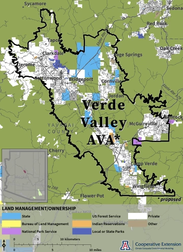
The Verde Valley American Viticultural Area (proposed)
Proposed in June 20171, the Verde Valley AVA in central Arizona covers an area in northeastern Yavapai County centered on the confluence of Oak Creek and the Verde River.
The Verde Valley AVA covers an area of about 219 square miles. About 79 square miles (36%) of the AVA is privately owned land. Federal and state entities manage the remainder2. The perimeter of the AVA follows the boundary description as described in the Verde Valley AVA petition and based on U.S. Geological Survey topographic maps1.
Verde Valley AVA (proposed) Climate

Jeremy Weiss
1 Verde Valley Wine Consortium, 2017: Verde Valley American Viticultural Area Petition, 24pp
2 The AZGEO Clearinghouse provided the city and public land ownership data layers and the U.S. Census Bureau provided the county and road data layers.

