Using geospatial technologies to understand dryland dynamics
![]() No.
51, May/June 2002
No.
51, May/June 2002
Using geospatial technologies to understand dryland
dynamics
by William L. Stefanov
|
"The large areal extent of the Central Arizona-Phoenix Long Term Ecological Research (CAP LTER) site (~7,900 km² centered on the Phoenix metropolitan area) necessitates a significant remote sensing component to many research activities, due to both the size of the study region and the ruggedness of the terrain in some areas." |
Introduction(Back to top) The large areal extent of the Central Arizona-Phoenix Long Term Ecological Research (CAP LTER) site (~7,900 km² centered on the Phoenix metropolitan area) necessitates a significant remote sensing component to many research activities, due to both the size of the study region and the ruggedness of the terrain in some areas. Remote sensing (as used in this article) is the detection, by satellite-based or airborne instruments, of energy reflected and/or emitted from surficial materials (e.g. plants, rocks, water) in wavelengths ranging from the visible (0.4-0.7 microns), near infrared (0.7-0.9 microns), shortwave infrared (0.9-3.0 microns), and mid-infrared (3.0-5.0 and 8.0-14.0 microns) portions of the electromagnetic spectrum. Measurement of this reflected and emitted energy in multiple wavelengths form spectra that can be used to identify inorganic and organic materials (both naturally occurring and built). Ratios of the energy measured in different wavelengths can also be used to highlight healthy vegetation and discriminate various kinds of minerals, rocks, and soils (and built materials derived from them). The use of remotely sensed data is crucial for scaling up detailed site-specific investigations, as well as for providing synoptic spatial and temporal information on urban/exurban surficial materials, patterns, and processes. Remote sensing is currently used in such areas of CAP LTER research as land cover characterization and change, vegetation dynamics, urban climatology, and geological/geomorphological studies. The following sections present some of this research to provide a general overview of the types of studies taking place within the CAP LTER project. Land cover characterization and change |
|
|
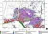
(Back to top) This land cover dataset is being used to investigate spatial landscape pattern and change in the Phoenix metropolitan region. Wu et al. (2001) have used a variety of landscape pattern analysis techniques and modeling approaches to investigate the current and historical pattern of patches in the CAP LTER region, as well as using this information to build sophisticated models of the mechanisms and trajectories of patch change. Their results suggest that the Phoenix regional landscape is becoming more fragmented with time, due primarily to human population increase driving ecosystem change. These changes are also taking place at multiple spatial scales; this research is continuing using various spatial scales of remotely sensed data. Wu et al. (2002) classified impervious surfaces (non-porous surfaces that prevent infiltration of water to sub-surface layers) in the Cave Creek, Arizona, watershed using high spatial resolution (3 meters/pixel) digital aerial orthophotographs. Accurate knowledge of the spatial extent and location of impervious surfaces in an urbanizing watershed is of great importance, as these surfaces have profound effects on the local hydrologic regime and stream flow patterns. The results of the Wu et al. (2002) study indicate that the majority of urbanized portions of the Cave Creek watershed are comprised of more than 30% impervious surface cover. This degree of impervious surface cover suggests that ecological processes in the urbanized watershed are at risk due to disruption of the normal hydrologic cycle. Urban climatology(Back to top) Land cover classifications derived from Landsat TM data are also being used to refine the atmospheric meso-scale model MM5. Currently up to 25 land cover/vegetation categories can be specified in the MM5 model. Each of these categories is characterized by physical parameters (albedo, moisture availability, emissivity, aerodynamic characteristics, thermal inertia), which are important for the energy, momentum and matter exchange between the land surface and the atmosphere. These exchange processes contribute directly to the simulated atmospheric stability and surface temperature derived from the model. Strong deviations between the land cover map obtained by the MM5 preprocessor TERRAIN and the existing land cover classification for the larger Phoenix metropolitan area have been noted. Work is ongoing to incorporate a new land cover map, based on the classified Landsat TM data, into MM5 and to study the impact of incorporation of the more detailed land cover data on modeled atmospheric patterns. Other ongoing projects related to urban climatology include a detailed study of interactions between regional climatic weather patterns, urban/rural temperature gradients, local topography, and rural land cover change from 1975 to 2000 using Landsat TM and Multispectral Scanner (MSS) data. Vegetation dynamics(Back to top) Stabler et al. (2000) used NDVI data (derived from Landsat TM) for the Phoenix area to determine if measured variations in urban microclimates were related to vegetation cover. During June and December 1999, in both early morning and afternoon, near-surface temperatures and humidities were measured at 0.1 mile (160 meter) intervals along multiple transects in the Phoenix metropolitan area in order to elucidate how land use and vegetation cover might affect microclimate. Agricultural and residential land uses had the highest relative humidities, dew point temperatures, and NDVI values, and the lowest air temperatures. Commercial land uses and industrial areas in the dry Salt River channel had the highest temperatures and the lowest NDVI values. Temperatures were generally negatively correlated to NDVI, while humidities and dew point temperatures were generally positively correlated to NDVI. These patterns of relationship between microclimate and NDVI suggest that Phoenix urban microclimates are a function of the interactive effects of vegetation and some other independent variable (most probably non-vegetated urban land cover types). |
|
|
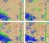
Large brushfire events have a significant effect on regional desert vegetation communities, particularly from the perspective of the invasion of exotic species such as grasses. Invasive grasses can replace previously well-spaced desert vegetation (such as cacti, creosote bush [Larrea tridentata], palo verde [Cercidium spp.], and mesquite trees [Prosopis spp.]) with a dense, continuous carpet of material that when dry presents a major fuel source for brushfires. Understanding of this revegetation process takes on a new importance as developments move into desert areas, both from the perspective of potential fire hazards and the potential acceleration of invasive grass establishment due to human disturbance effects. Wentz et al. (2001) used Landsat MSS, TM, and Enhanced Thematic Mapper Plus (ETM+) data to build a brushfire chronology in the northeast Phoenix metro region using variations in soil reflectance, vegetation abundance, and visible to near infrared albedo associated with known fire scars. The results of this pilot study indicate that fire scar regions are easily detectable using surface albedo and simple reflectance band combinations. Positive correlation between fire scar age and woody vegetation abundance is also observed. Future research will include investigation of grass species abundance in the fire scar regions; characterization of surface soil chemistry in fire scars of different age and soil type; use of high spatial and spectral resolution data from the Moderate Resolution Imaging Spectroradiometer (MODIS)/Advanced Spaceborne Thermal Emission and Reflection Radiometer (ASTER) Simulator (MASTER) to perform remote mineralogical analysis of fire scar soils; and GIS modeling of potential linkages between increased human presence and increased fire frequency. An ongoing study is using SAVI values derived from Landsat ETM+ data and detailed measurements of plant biovolume obtained from throughout the CAP LTER study area to produce a calibration curve for the vegetation index data. Construction of a calibration curve will allow for conversion of the semi-quantitative SAVI values to biovolume for the entire CAP LTER study area. Some applications of such data would be calculation of regional net primary productivity, carbon storage, and spatial patterns of biomass distribution in the urban ecosystem. Geology/Geomorphology(Back to top) |
|
|
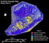
Stefanov and Applegarth (2001) used data collected by the airborne Thermal Infrared Multispectral Scanner (TIMS) instrument with laboratory thermal infrared spectroscopy to create mineralogical soil maps and maps of grain size distribution in the McDowell and White Tank Mountains of central Arizona. Both of these mountain ranges are located along the current Phoenix metropolitan urban fringe, and represent natural laboratories where the effects of human encroachment on surficial geologic processes can be observed and monitored. Soil mineralogical maps, and indices of soil development (relative proportion of weathered to primary rock-forming minerals) and gravel+bedrock (relative proportion of bedrock and gravel- to boulder-sized surficial particles to smaller particles) percentages were developed using the spectral properties of minerals and rocks in the mid-infrared wavelengths. Major results of this work suggest that significant soil development is taking place on semiarid to arid hillslopes in the current climatic regime, and that the dominant particle size on hillslopes controls the style of pediment formed at the mountain front (small particle-dominated slopes are correlated with alluvial slopes, whereas large particle-dominated slopes are correlated with bedrock pediments). |
|
|
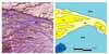
Data acquired by the TIMS and an airborne Landsat TM simulator (known as NS001) were used by Robinson et al. (1998) to map out various Quaternary alluvial fan sequences on the western side of the White Tank Mountains (located to the west of the Phoenix metropolitan area). Band ratios of the NS001 data sensitive to the presence of clay minerals and iron oxides proved to be very useful in discriminating different surficial units. Maps of the surficial units were used in concert with cosmogenic radionuclide dating techniques to determine the ages of two units in the area: a mid-Pleistocene surface (approximately 0.5 million years old) and an Oldest Pleistocene surface (approximately 1.5 - 1.7 million years old). These age constraints, together with the geomorphic character of the surficial deposits, are useful for constructing flood histories and flood hazard maps for Quaternary deposits likely to be the site of future developments as urbanization of the region continues to expand. Ramsey and Arrowsmith (2001) are examining geomorphic changes following brushfire events using many of the same fire scar regions as Wentz et al. (2001). They are using a multiscale remote sensing approach incorporating balloon-mounted cameras, Landsat TM and ETM+ data, and visible through mid-infrared data collected by the Advanced Spaceborne Thermal Emission and Reflection Radiometer (ASTER) on board the orbiting Terra satellite. Initial results of their study suggest that removal of vegetation by fire leads to a decrease in surface roughness and interception of water runoff coupled with a loss of surface material strength. This allows subsequent precipitation events to remove more soil material and fosters increased headward erosion, leading to more dissection of drainage basins. Ongoing work includes the integration of field and remotely sensed information from burned (and corresponding unburned) areas to create an automated fire scar detection algorithm that can be used in other urban regions. One of the main goals of this research is to ultimately create models of fire hazard and flooding potential based on both the types and distributions of natural materials (i.e. geologic material and vegetation) and human modifications to the landscape (built structures, roadways, etc.). Two additional research initiatives are underway at Arizona State University that are linked to the CAP LTER project: the ASTER Urban Environmental Monitoring (UEM) program and the Arizona Geoinformatics project. The ASTER instrument, one of a suite of sensors on the orbiting Terra satellite, acquires surficial data from the visible through mid-infrared wavelength regions of the electromagnetic spectrum at resolutions ranging from 15-90 meters/pixel. The UEM program is collecting ASTER data over 100 global urban centers (including Phoenix, Arizona and Baltimore, Maryland). Several dryland cities are included in the UEM program, such as Kuwait City, Kuwait; Riyadh, Saudi Arabia; Tel Aviv, Israel; Baghdad, Iraq; Las Vegas, Nevada; and Tucson, Arizona. A complete listing of UEM cities is available at the UEM website (listed below under Additional Web Resources). Data acquisition for each UEM city is attempted at least twice per year (both day and night), and will be continued over the projected 6-year life of the satellite (Stefanov, Christensen and Ramsey 2001). The classification techniques and results obtained from the study of the Phoenix metropolitan area are being applied to ASTER data and therefore have the potential to extend CAP LTER results to the global scale using data from other cities. The primary data products of the UEM program are first-order land cover classifications (vegetated to non-vegetated, sparse urban to dense urban, water) for the 100 cities that will enable basic comparisons of urban structure, vegetation abundance, and land cover change. Collaborations with local investigators in each city are actively sought to encourage multinational research efforts, as well as to use the ASTER data to pursue more detailed research questions. The Arizona Geoinformatics project is part of an ongoing National Science Foundation initiative to increase and improve the use of information technology in the geological sciences. The primary goal of this project is to create a Web-searchable database of available digital information for the Colorado Plateau-Transition Zone-Basin & Range geologic provinces that includes geophysical data, remotely sensed data (comprised of ASTER data initially), digital elevation models, and geologic maps (Keller et al. 2001). In addition to being able to search the database using a Web browser interface, the user will also have the ability to perform data queries and simple image processing (done "on the fly") with output downloadable as standard shapefiles and geotiff images. The initial geographic focus of the project is a corridor from Flagstaff to Tucson, Arizona, but the project will eventually encompass all of Arizona and New Mexico as well as portions of Utah, Colorado, and Texas. It is evident from the preceding discussion that remotely sensed data are an important component of many diverse areas of research within the CAP LTER and other research initiatives. The use of remotely sensed data in ecological, biological, geological, and geographical research is only expected to increase as higher spatial and spectral resolution data become available from new sensors. In addition, recent advances in the accessibility and use of radar and lidar remote sensing systems offer the potential for remote sensing of highly detailed topography, vegetation structure, soil moisture, and subsurface structure in urban and exurban environments. The combination of traditional field-based research with the synoptic view obtained using remotely sensed data offers the potential for exciting new insights into ecosystem functioning, and our role in it, at all scales from local to global. AcknowledgementsI would like to thank J. Ramon Arrowsmith, Susan Grossman-Clarke, Linda Stabler, and Wanli Wu (all at Arizona State University) for providing information on their various research projects for this article. References(Back to top) Grimm, N.B., J.M. Grove, S.T.A. Pickett, and C.L. Redman. 2000. Integrated approaches to long-term studies of urban ecological systems. Bioscience 50(7):571-584. Grossman-Clarke, S., D. Hope, P. Hyde, W. Stefanov, H.S. Fernando, and N.B. Grimm. 2002. Assessment of temporal and spatial characteristics of nitrogen dry deposition in the Phoenix metropolitan region. Poster presented at the Central Arizona-Phoenix Long Term Ecological Research Fourth Annual Poster Symposium, Tempe, Arizona, January 2002. http://caplter.asu.edu/Symposia/Symp2002/GrossmanClarke.pdf (Accessed 18 June 2002). Keller, G.R., R. Arrowsmith, M. Fouch, A. Gates, N. Hicks, V. Kreinovich, K. Mickus, S. Reynolds, S. Richard, and W. Stefanov. 2001. The southern Colorado Plateau and adjacent Basin and Range Province: A testbed for geoinformatics and data integration. Geological Society of America Abstracts With Programs 33(6):A175. Ramsey, M.S. and J.R. Arrowsmith. 2001. New images of fire scars may help mitigate future natural hazards. American Geophysical Union Eos Transactions 82:393, 397-398. Robinson, S.E., J.R. Arrowsmith, D.E. Granger, and F.M. Phillips. 1998. Using remote sensing and cosmogenic nuclides to determine the geometry of alluvial fan deposits and the timing of their deposition. Geological Society of America Abstracts With Programs 30(7):A139. Stabler, L.B., C.A. Martin, K. Peterson, and J. Blank. 2000. Effects of urban land use on vegetation cover and microclimate. Ecological Society of America 85th Annual Meeting Abstracts, 373. Stefanov, W.L. and M.T. Applegarth. 2001. Geomorphic analysis of semiarid landforms using mid-infrared spectroscopy and remote sensing. American Geophysical Union Eos Transactions 82, Abstract H42D - 0393. Stefanov, W.L., P.R. Christensen, and M.S. Ramsey. 2001. Remote sensing of urban ecology at regional and global scales: Results from the Central Arizona-Phoenix LTER site and ASTER Urban Environmental Monitoring program. In Remote Sensing of Urban Areas, ed. C. Jurgens. Regensburger Geographische Schriften 35:313-321 (on supplemental CD-ROM). Stefanov, W.L., M.S. Ramsey, and P.R. Christensen. 2001. Monitoring urban land cover change: An expert system approach to land cover classification of semiarid to arid urban centers. Remote Sensing of Environment 77:173-185. Wentz, E., S. Anderson, W. Stefanov, and J. Briggs. 2001. Desert fire history and effects on the Phoenix, Arizona, metropolitan area. In Proceedings of the IEEE/ISPRS Joint Workshop on Remote Sensing and Data Fusion Over Urban Areas, 154-158. Wu, J., J.L. David, G.D. Jenerette, M. Luck, and S. Berling-Wolff. 2001. Modeling land use change and ecosystem processes of the Phoenix metropolitan landscape. Poster presented at the Central Arizona-Phoenix Long Term Ecological Research Third Annual Poster Symposium, Tempe, Arizona, January 2001. http://caplter.asu.edu/Symposia/symp2001/Wu_etal_Synthesis.pdf (accessed 18 June 2002). Wu, J. and S.A. Levin. 1997. A patch-based spatial modeling approach: Conceptual framework and simulation scheme. Ecological Modelling 101:325-346. Wu, W., J. Wu, D. Stuart, and J. Harris. 2002. Spatial patterns of impervious surface cover in the Cave Creek watershed, Phoenix metropolitan region. Poster presented at the Central Arizona-Phoenix Long Term Ecological Research Fourth Annual Poster Symposium, Tempe, Arizona, January 2002. http://caplter.asu.edu/Symposia/Symp2002/Wwu.pdf (accessed 18 June 2002). |
![]()
(Back to top)
William L. Stefanov is a Faculty Research Associate at the:
Geological Remote Sensing Laboratory
Department of Geological Sciences
Arizona State University
Tempe, AZ 85287-6305
USA
You can reach him for comment by email at will.stefanov@asu.edu
(Back to top)
Central Arizona-Phoenix Long Term Ecological Research Project
http://caplter.asu.edu
The official web site for this project.
Arizona State University Geological Remote Sensing Laboratory
http://elwood.la.asu.edu/grsl/
ASTER Urban Environmental Monitoring Project
http://elwood.la.asu.edu/grsl/UEM/
Arizona Geoinformatics Project
http://activetectonics.la.asu.edu/azgeoinf/index.html
Multi-Spectral Remote Sensing of Brush Fire Scars in Arid Urban Regions:
Analysis of Future Fire and Flooding Hazards
http://activetectonics.la.asu.edu/Fires_and_Floods/index.html
This web site provides more information on the fire research conducted by Mike
Ramsey and Ramon Arrowsmith, cited in this article.
About the Arid Lands Newsletter