Conflict Resolution and Transboundary Water Resources
![]() No. 44, Fall/Winter 1998
No. 44, Fall/Winter 1998
Conflict Resolution and Transboundary Water Resources
The Rio Grande and the Colorado are the two major rivers of the U.S.-Mexico borderlands. Both rivers rise in Colorado. From there, the Rio Grande flows generally southward until it reaches the sister cities of El Paso, Texas/Ciudad Juárez, Mexico. From that point on it forms the border between the United States and Mexico, flowing generally southeastward until it enters the Gulf of Mexico. The Colorado flows generally southwestward or southward in its course to the head of the Sea of Cortés (Gulf of California). Primarily a transnational river, it forms the international border between the U.S. and Mexico for a short stretch southwest of Yuma, Arizona. | 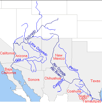 |
Maps copyright Len Milich. This map originally appeared in Environment 40(8): 38.
About the Arid Lands Newsletter