< Back to Verde Valley AVA (proposed) Soil
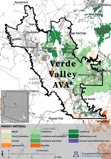
Parent Material
Limestone is a known parent material occurring in the central part of the proposed Verde Valley AVA, east of the Verde River.1 Limestone and sandstone, limestone and shale, sandstone, and basalt appear in adjacent areas. Granite and igneous rock are present in locations along the valley floor.
Parent material is the type of bedrock from which soil forms. As a component of vineyard soils, it influences water infiltration, storage, and drainage, erodibility, pH, nutrient availability, and heat absorption, which affect root, canopy, and fruit growth.
Jeremy Weiss
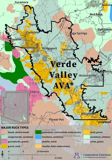
Major Rock Types
Gravel and sand are the most abundant rock types in the proposed Verde Valley AVA for many areas along the valley floor and to the west of the Verde River.2 Conglomerate and sandstone also occur in several areas to the west of the Verde River, as well as to its east. Basalt and alkaline basalt are present in areas along the northeastern and northwestern boundaries. Sandstone and siltstone also are present in the northwestern part of the AVA.
Major rock types are the most common solid, loose, and unstratified rocks, defined by composition, texture, and origin. As a component of vineyard soils, they influence water infiltration, storage, and drainage, erodibility, pH, nutrient availability, and heat absorption, which affect root, canopy, and fruit growth.
Jeremy Weiss
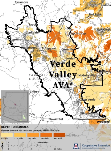
Depth to Bedrock
Known depths to bedrock are less than 12 inches for much of the east-central part of the proposed Verde Valley AVA, although depths between 24 and 36 inches and between 36 and 48 inches occur in some adjacent areas.1 Depths less than 12 inches and between 12 and 24 inches exist in the northwestern part.
Depth to bedrock represents the distance from the soil surface to the top of a restrictive layer, such as bedrock and other dense layers. As a component of vineyard soils, such restrictive layers can impede water drainage and restrict root depth.
Jeremy Weiss
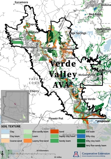
Texture
Fine sandy loam, loam, sandy clay loam, sandy loam, silty clay loam, silt loam, and very fine sandy loam are known to occur in areas throughout the proposed Verde Valley AVA.1 Sand is common along surface water features like the Verde River and Oak Creek. Areas of loamy fine sand exist in eastern and northeastern parts of the AVA.
Texture represents the relative proportions of mineral grains in soil based on their size. As a component of vineyard soils, it influences water infiltration, storage, and drainage, erodibility, pH, nutrient availability, and heat absorption, which affect root, canopy, and fruit growth.
Jeremy Weiss
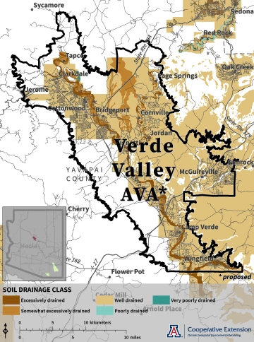
Drainage Class
Much of proposed Verde Valley AVA has well-drained soils.1 Excessively and somewhat excessively drained soils are common along surface water features like the Verde River and Oak Creek. An area of somewhat excessively drained soil also exists in the north-central part of the AVA.
Drainage class refers to the rate at which water drains from soil, how frequently water occurs in soil, and at which soil layers water is found. As characteristics of vineyard soils, these conditions influence soil moisture and nutrient and oxygen availability, which affect root, canopy, and fruit growth.
Jeremy Weiss
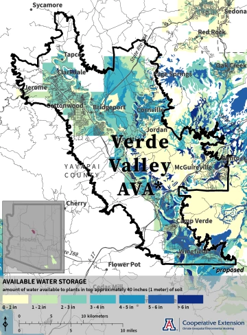
Available Water Storage
Several areas in the northern half of the proposed Verde Valley AVA have available water storage in the top approximately 40 inches of soil between two and five inches.1 Several areas along the northwestern and eastern boundaries of the AVA, as well as along surface water features like the Verde River and Oak Creek, have values less than two inches. Values between one and six inches are typical for much of the southern half of the AVA adjacent to the Verde River.
Available water storage represents the amount of water soil can store, in this case in the top approximately 40 inches (1 meter), for plants. As a characteristic of vineyard soils, it influences how much rain, melted snow, and irrigation can be absorbed as well as irrigation frequency.
Jeremy Weiss
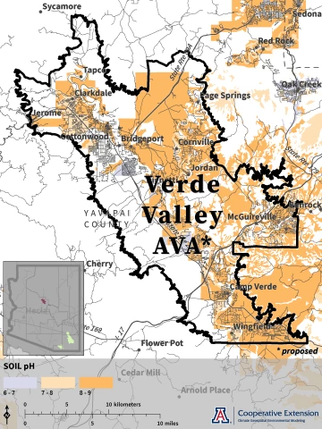
pH
Soil pH between 8 and 9 is known to occur for much of the proposed Verde Valley AVA east of the Verde River, as well as in the northwestern part of the AVA.1 Soil pH between 7 and 8 exists in areas near surface water features like the Verde River and Oak Creek, in addition to the northwestern part of the AVA.
Soil pH reflects the relative acidity (values less than 7) or alkalinity (values greater than 7) of soil. As a component of vineyard soils, it influences nutrient availability, which affects root, canopy, and fruit growth.
Jeremy Weiss
1 Gridded Soil Survey Geographic (gSSURGO) Database for Arizona, United States Department of Agriculture, Natural Resources Conservation Service, July 2020 Release. Not all areas have complete or available data.
2 US Geological Survey Mineral Resources, Arizona geologic map data

