< Back to Climate Viticulture Newsletter
Hello, everyone!
This is the 2020 May issue of the Climate Viticulture Newsletter – a quick look at some timely climate topics relevant to winegrape growing in Arizona and New Mexico.
A Recap of April Temperature and Precipitation
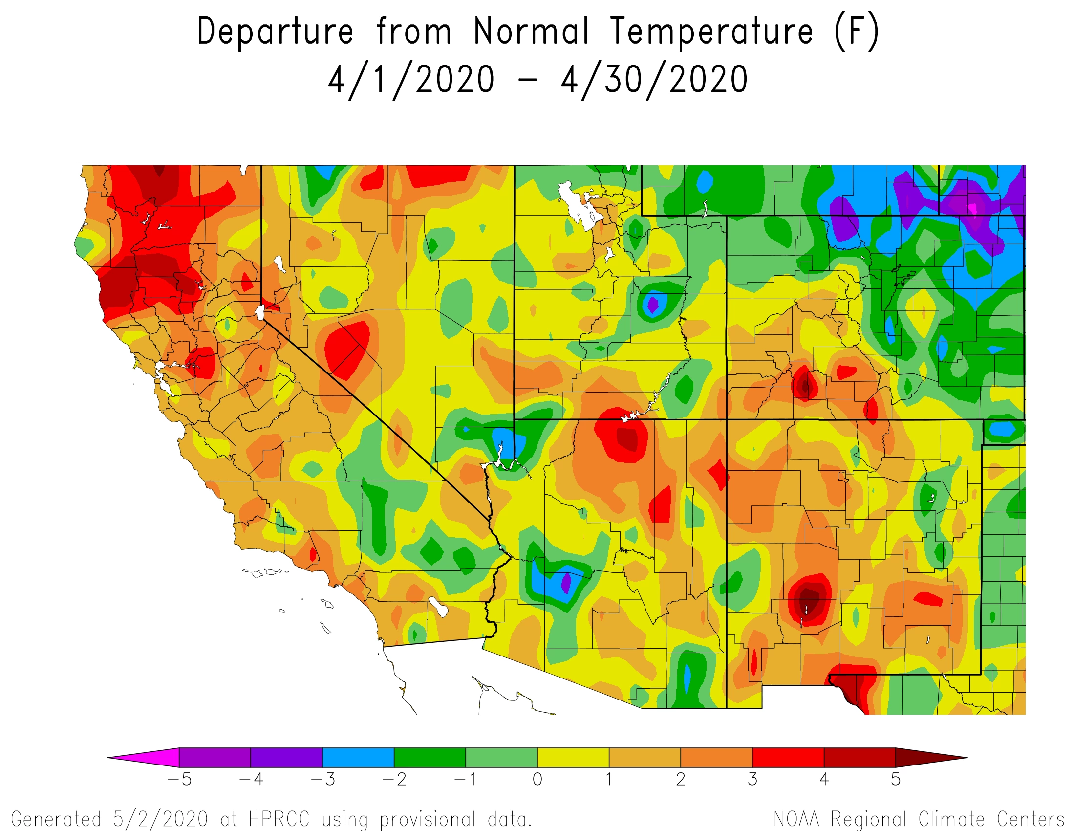
Average temperatures for the month of April were near the long-term normal for much of the southwestern half of Arizona and northeastern part of New Mexico (yellow and light green areas on map). Between these two areas, temperatures were largely 1°F to 3°F above the 1981-2010 average (light and dark orange areas on map). Perhaps the most notable thing about temperature last month was the record heat during the last week across both Arizona and New Mexico. For relatively cooler winegrape growing areas in the region, our guess is that the unseasonably warm temperatures had vines racing through their early growth stages. More on this below.
NOAA ACIS
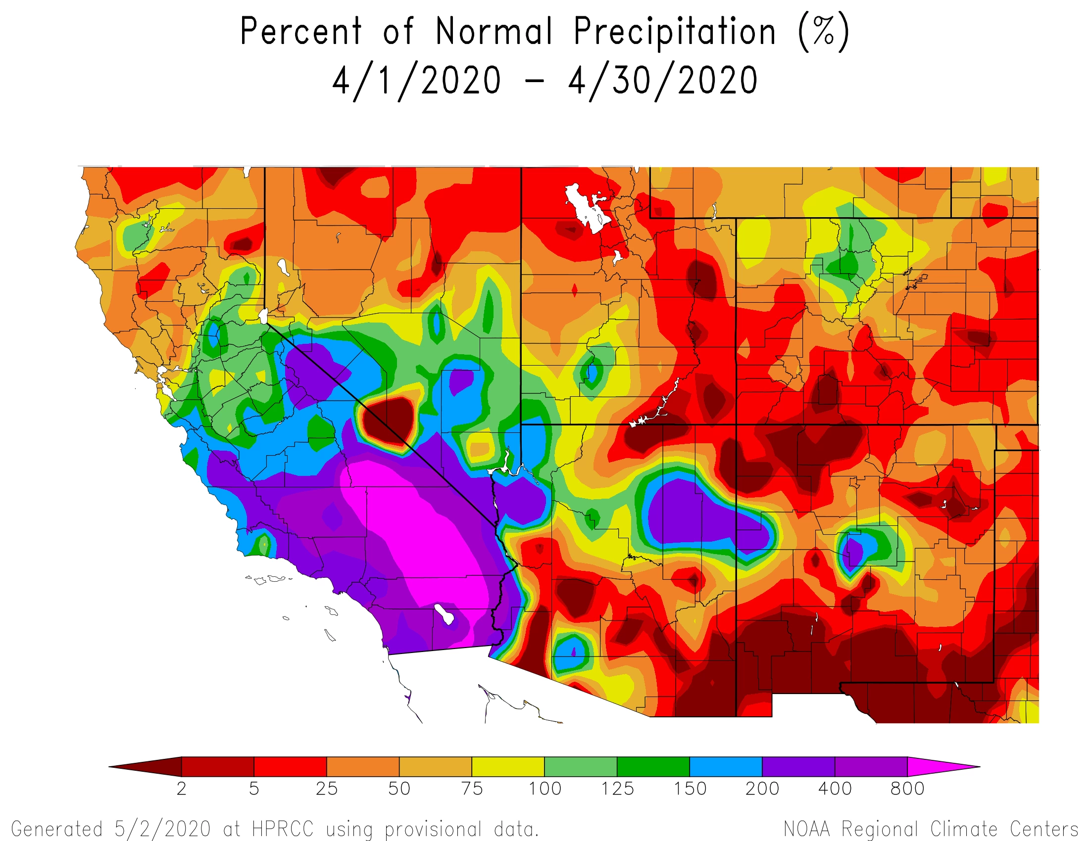
Monthly precipitation totals were below average for much of the region (orange and red areas on map). A few exceptions to this include areas in northeastern and extreme western Arizona where monthly totals were more than 150% of the 1981-2010 normal (blue and purple areas on map). Thunderstorms unfortunately were part of the precipitation package last month for the proposed Verde Valley American Viticultural Area (AVA). Hopefully, no hail or other storm damage occurred. With a mostly dry and windy month punctuated by record heat for many locations, however, we’re thinking that soil moisture banked over the winter and early spring is being spent more quickly than last year.
NOAA ACIS
The Outlook for May Temperature and Precipitation
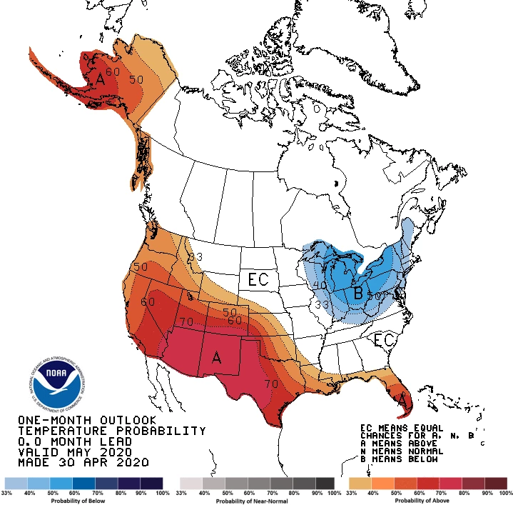
Given how April ended and May started, it probably won’t surprise you that there is a strong increase in chances for above-average temperatures across the entire region for this month (dark red area on map). This would be quite a difference from May 2019! For the warmest winegrape growing areas in the region, like the Willcox and proposed Verde Valley AVAs in Arizona and the Mesilla Valley and Mimbres Valley AVAs in New Mexico, May begins the time of year when record-high temperatures can mean excessive heat for vines. Such conditions are expected during the first week of the month for southeastern and north-central Arizona and southern New Mexico. We’ll talk more about potential impacts in the vineyard from excessive heat at this time of the year below.
NOAA CPC
There is a slight increase in chances for above-normal precipitation across New Mexico (green areas on map), except for the far northern and eastern parts of the state where equal chances for above-, near-, or below-average precipitation totals exist (white area on map). Equal chances also exist for all of Arizona. May is a relatively dry month, except perhaps for the eastern plains of New Mexico that experience the thunderstorm season of the Southern Plains. In fact, its arrival this year is driving the slight increase in chances for above-average rainfall this month (green areas on map). Let’s hope that any precipitation events that do occur will not negatively affect flowering and fruit set.
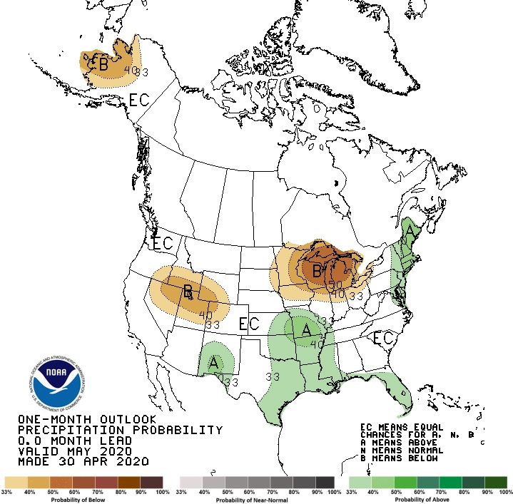
NOAA CPC
'Tis the (Wildland Fire) Season
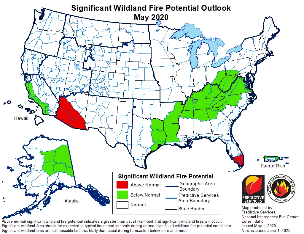
With warm temperatures, low precipitation, low humidity, and wind, fine fuels like grasses, leaves, twigs, and shrubs are drying out rapidly. There is an above-normal potential this month for significant wildland fires for areas in Arizona south and west of the Mogollon Rim and for part of the New Mexico ‘boot heel’ (red area on map). Otherwise, the potential in the region is near normal (white area on map). Smoke taint, which can lead to undesirable flavors and aromas in wines, fortunately is a relatively low risk for the region. This is because the wildland fire season peak at this time of the year does not coincide with the ripening and harvest period when fruit has a higher potential for smoke uptake.
NICC NIFC
Heat Accumulation So Far This Year
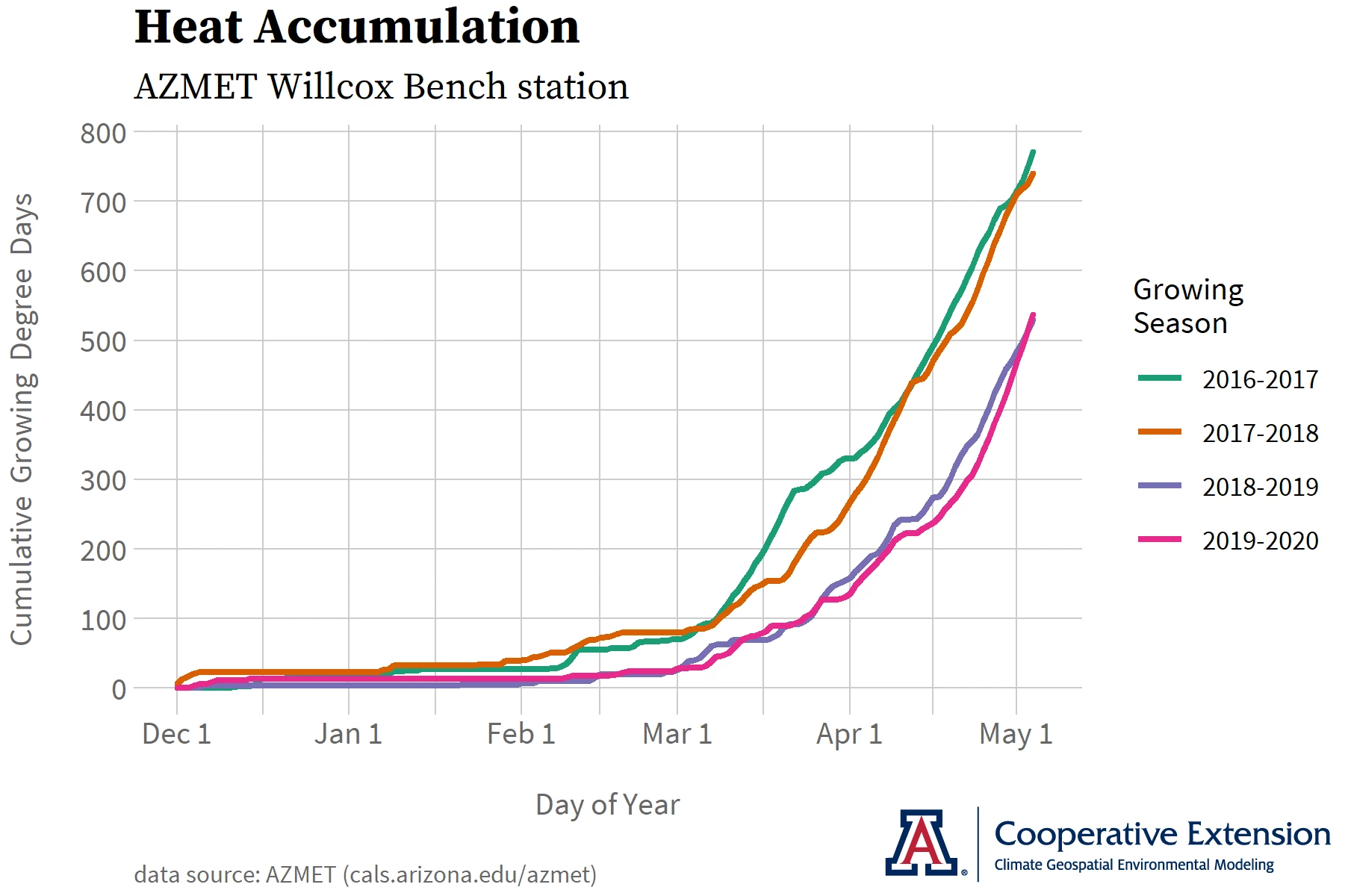
At the Arizona Meteorological (AZMET) Network Willcox Bench station, where we’ve been tracking conditions related to the start of the growing season this year, the late April heat brought cumulative growing degree days back up to the level they were at this time last year, after falling behind during the middle of the month (pink and purple lines on graph). Based on growing-degree-day information from the National Phenology Network, this also appears to be the case for other locations in the Willcox, Sonoita, and proposed Verde Valley AVAs in Arizona, as well as the Mesilla Valley, Mimbres Valley, and Middle Rio Grande Valley AVAs in New Mexico. This suggests that vine growth stages at the start of May are similar to those observed last year.
Jeremy Weiss
The Relationship between Temperature and Vine Growth Rate
Not all temperatures are equal for vines during the growing season. Growth starts and occurs slowly around 50°F, climbs to its maximum rate by about 75°F, and then slows back down and stops around 100°F.1
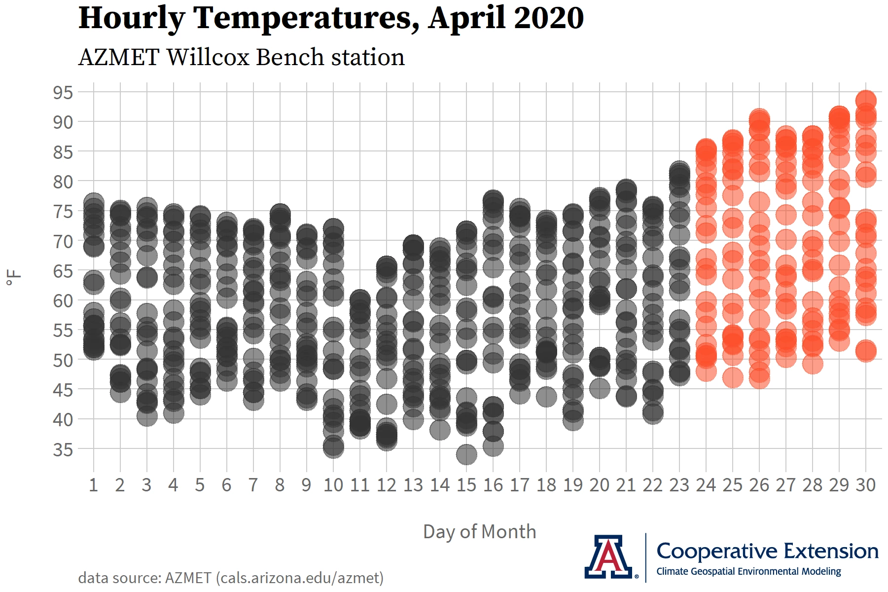
Hourly data from the AZMET Willcox Bench station during roughly the first three weeks of April (dark gray dots on graph) show that the warmest temperatures on most days were close to 75°F. Vines nearby likely were growing near or at their maximum rate on these afternoons. During the relative heat of the last week (dark orange dots on graph), however, the warmest temperatures were between 85°F and 95°F and likely slowed down vine growth rate. For relatively cooler winegrape growing areas in the region, vines instead may have stayed closer to their maximum growth rate and raced through their early growth stages during the late April heat.
The warmest temperatures last month at the AZMET Willcox Bench station probably did not lead to any negative impacts. Record heat in May, which is forecast for the end of the first week of the month, however, gets uncomfortably close to temperatures that can decrease fruit set by reducing pollen viability.2 Excessive heat and its impacts on winegrape growing at other times of the growing season will be a topic we return to in future newsletter issues.
1Gladstones
Jeremy Weiss
Wrapping up the Classification Series with Biologically Effective Degree Days
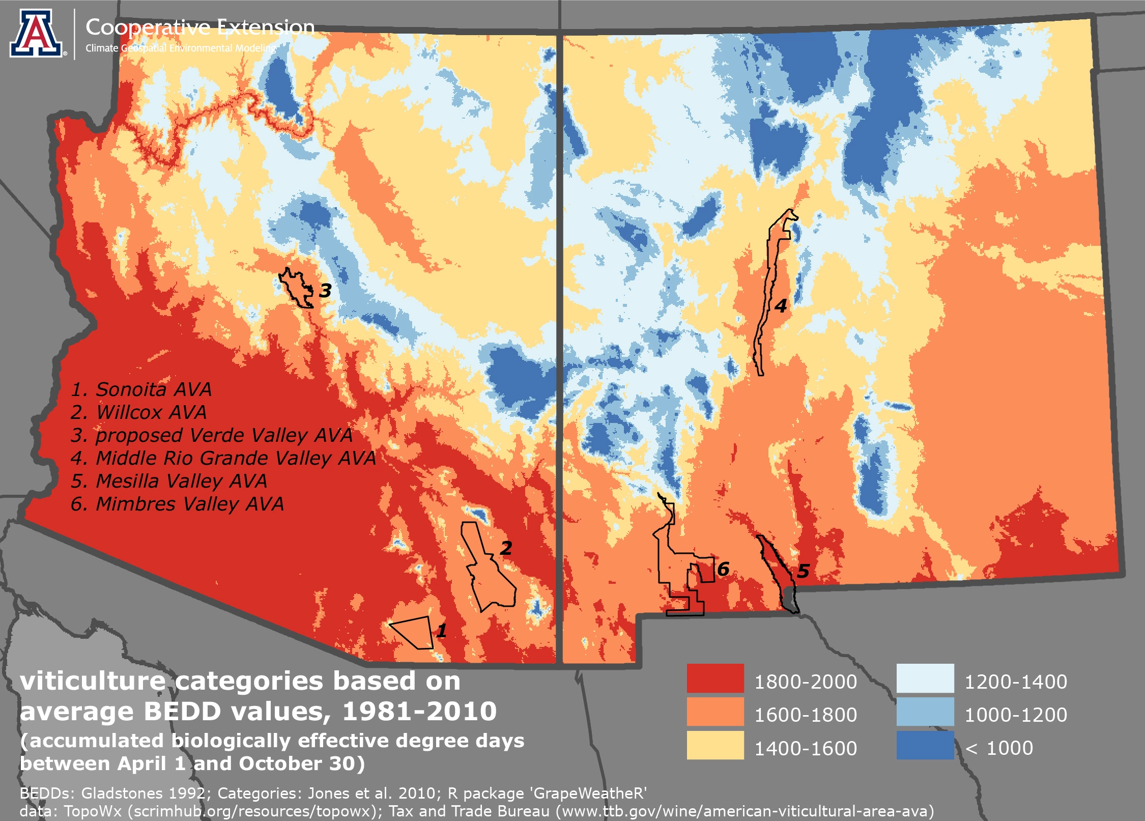
The relationship between temperature and vine growth rate is one of the inputs for calculating Biologically Effective Degree Days (BEDDs), the last stop in our tour of climate-viticulture classifications. With additional inputs that consider day length, diurnal temperature range, and the accumulation of growing degree days during the growing season, BEDDs are more complex, but still similar to the other classifications we’ve seen. John Gladstones included BEDDs in his book, Viticulture and Environment, as a method for predicting winegrape maturity dates.
Long-term average values for BEDDs across Arizona and New Mexico reflect those from the Growing Season Temperature, Winkler Index, and Huglin Index classifications. For instance, AVAs in both states lie towards the warmer end of the winegrape-growing spectrum (orange and red areas on map). To put this in perspective, such categories also characterize the Barossa Valley and Margaret River Geographical Indications in Australia, the Lodi AVA in central California, and the Jerez-Xérès-Sherry Denominación de Origen Protegido in southwestern Spain.3
As with the other climate-viticulture classifications, however, we consider direct comparisons like this to be useful only in a general context. Further examination of additional climate and other environmental factors is necessary to better understand viticulture, terroir, and varietal suitability in Arizona and New Mexico. We will be doing just that in coming newsletter issues.
3Jones and others
Jeremy Weiss
For those of you in southeastern Arizona, Cooperative Extension manages an email listserv in coordination with the Tucson forecast office of the National Weather Service to provide information in the days leading up to agriculturally important events, like record-high temperatures and critical fire weather conditions. Please contact us if you'd like to sign up.
Please feel free to give us feedback on this issue of the Climate Viticulture Newsletter, suggestions on what to include more or less often, and ideas for new topics.
Did someone forward you this newsletter? Please contact us to subscribe.
Stay healthy!
With support from:
