< Back to Climate Viticulture Newsletter
Hello, everyone!
This is the 2019 October issue of the Climate Viticulture Newsletter – a quick look at some timely climate topics relevant to winegrape growing in Arizona and New Mexico.
A Recap of September Temperature and Precipitation
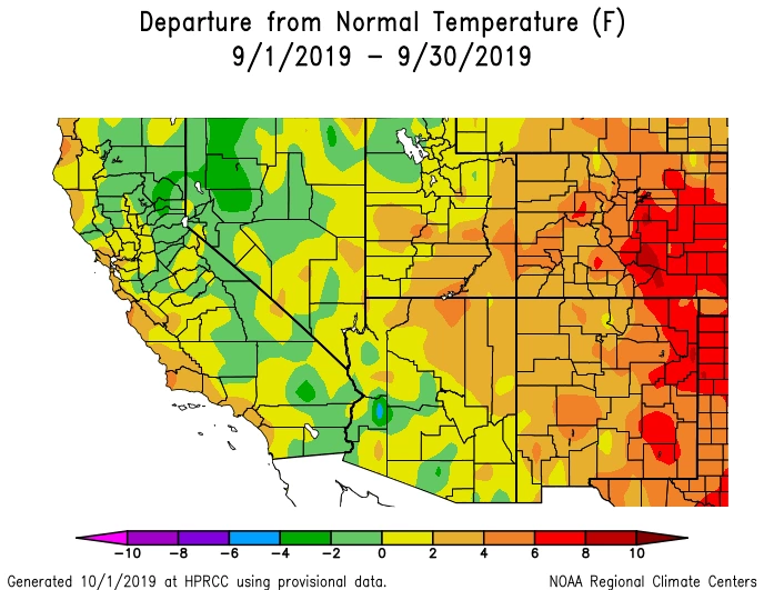
Monthly average temperatures in September were 2° to 6° Fahrenheit above the 1981-2010 average for northeastern Arizona and much of New Mexico (orange areas on map), with parts of the eastern plains in New Mexico 6° to 8° Fahrenheit above average (red areas on map). Temperatures were mostly within 2° Fahrenheit of normal for the rest of the region, particularly across western and southern Arizona (yellow and light green areas on map). For the first time in a few months, warmer-than-average temperatures didn’t translate to impacts on vines from excessive heat. In contrast, it may have helped with ripening fruit for vineyards in relatively cool winegrape-growing areas like those in northern New Mexico.
NOAA ACIS
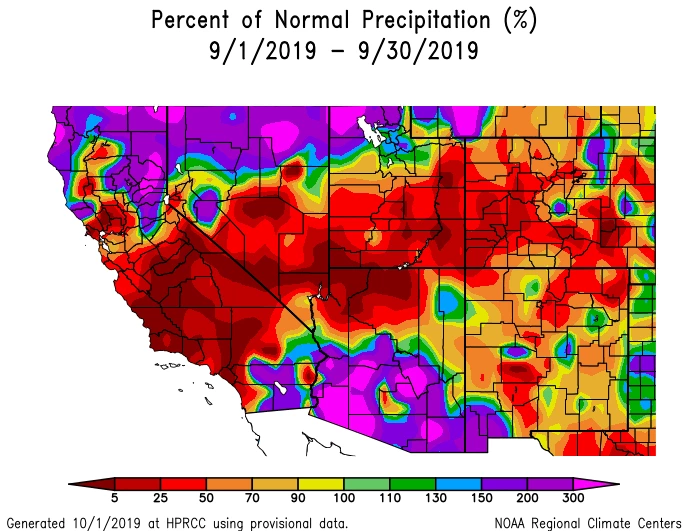
Monthly precipitation totals ran the gamut across Arizona, with much of the northern part of the state measuring less than 50% of normal (red areas on map) and much of the southern part more than 150% (purple and magenta areas on map), the latter a result largely tied to where moisture from Hurricane Lorena was converted to rainfall. The bootheel region of New Mexico also recorded the influence of this tropical cyclone with above-average precipitation (blue and purple areas on map), whereas much of the rest of the state experienced below-average amounts (orange and red areas on map). Hopefully, locations with additional rainfall last month benefited from higher soil moisture levels while not being challenged by any excessive precipitation.
Generally speaking, the end of September also means the close of the 2019 monsoon. If you’re looking for an end-of-the-season wrap-up, technical summaries of monsoon precipitation at a number of weather stations in the region are available from the Climate Science Applications Program at the University of Arizona.
NOAA ACIS
The Outlook for October Temperature and Precipitation
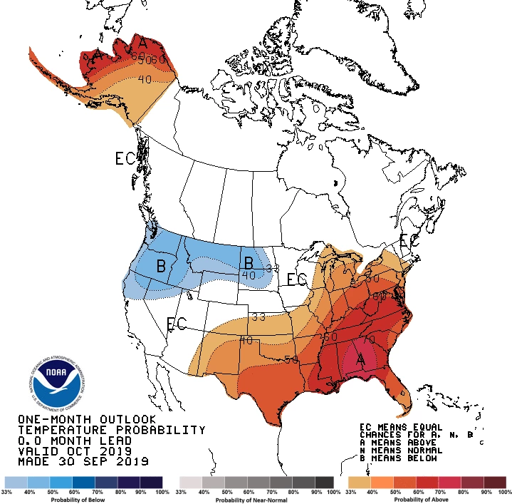
A slight increase in chances for above-average temperatures exists for extreme eastern Arizona and all of New Mexico (orange areas on map). Equal chances for above-, near-, or below-normal temperatures for the month exist for the rest of the region (white area on map). With vineyard irrigation or higher soil moisture from recent rains, warmer-than-average temperatures at this time of year may help vines continue accumulating carbohydrates through photosynthesis and supporting the second seasonal peak in root growth, particularly in relatively cool winegrape-growing areas like those in northern New Mexico.
NOAA CPC
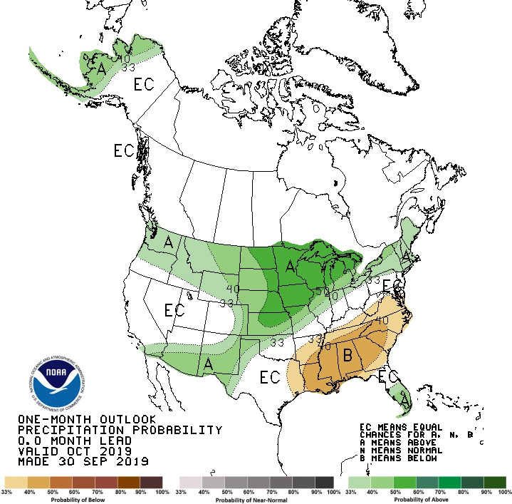
There is a slight increase in chances for above-normal precipitation across the southern two-thirds of Arizona and all but northwestern New Mexico (green areas on map). Otherwise, equal chances exist for above-, near-, or below-average precipitation totals for the month (white area on map). Like last month, higher odds for additional rainfall are due in part to the potential for tropical cyclones to our south in the eastern tropical Pacific Ocean to send moisture northward and into the region. Any extra rainfall would benefit soil moisture levels and growth of vineyard cover crops as we head towards the end of the growing season.
NOAA CPC
Heat Accumulation So Far This Year
A variable that helps us understand and predict the timing of vine growth stages is the accumulation of heat during the year, often quantified by the sum of growing degree days (GDDs).
As mentioned in previous newsletter issues, timing of vine growth stages appears more sensitive to cooler- or warmer-than-normal temperatures during spring. If growth stages earlier in the year like budburst and flowering are behind or ahead of their average dates, the timing of subsequent phenological stages like the start of ripening and harvest often follow suit.
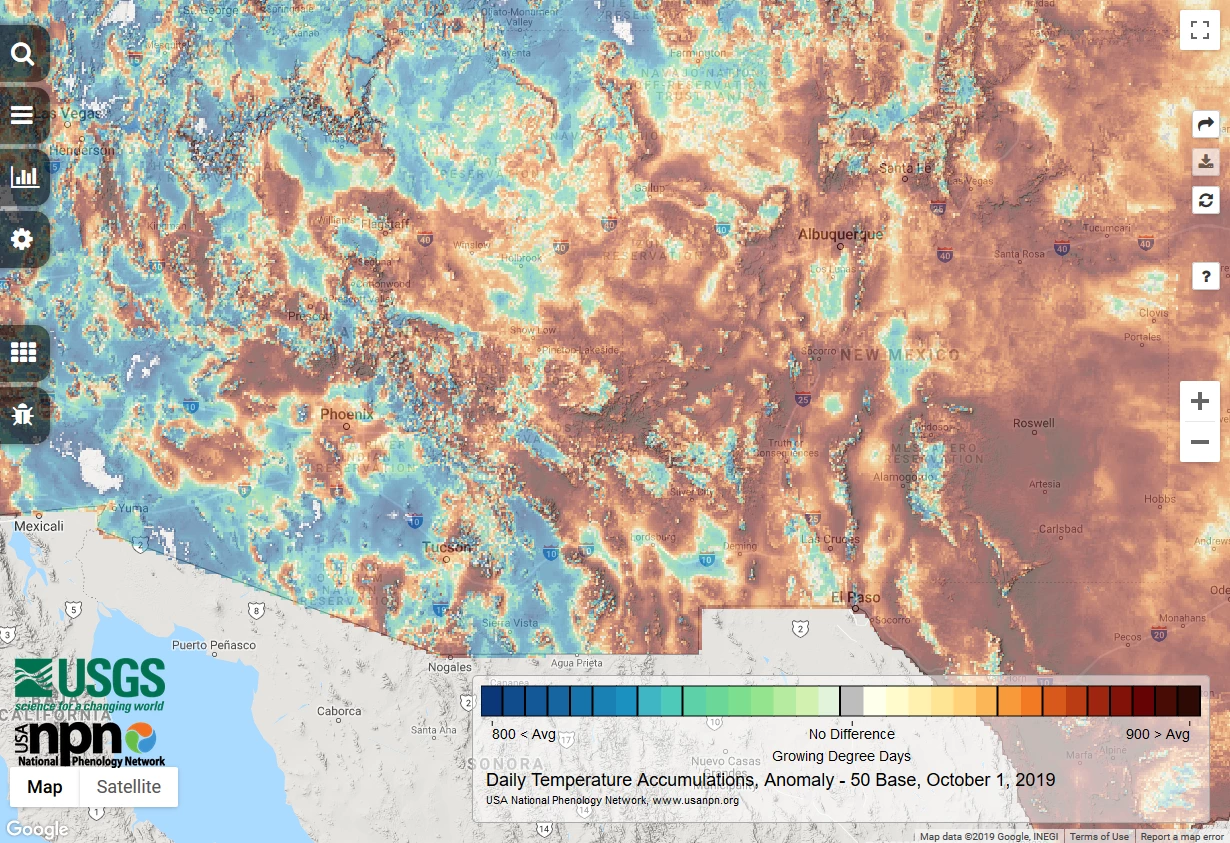
Such effects of relatively cool May and June temperatures across Arizona look to still be hanging around, as we start October with accumulated GDDs that are below average values for several parts of the state (blue and green areas on map). This is the case, for example, in the Sonoita, Willcox, and, to a lesser degree, locations within the proposed Verde Valley American Viticultural Areas (AVAs). Heat accumulations in several other parts in the state, however, are above average (yellow, orange, and brown areas on map). In New Mexico, where May temperatures weren’t as much below normal, heat accumulations are slightly to much above-average for almost all of the state (yellow, orange, and brown areas on map).
Current accumulated GDDs also are lower than values from this time last year for several winegrape growing areas, with reports so far of ripening and harvest dates being about two weeks later than those in 2018. Now that the last of the 2019 harvests are taking place, we’d be interested in hearing from you if you observed similar or different conditions in your vineyard this growing season.
USGS NPN
A Look towards the First Fall Freeze
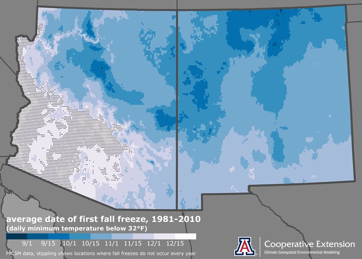
One telltale sign that the growing season is coming to an end is when daily minimum temperatures start to drop below freezing and vines start to drop their leaves. We can expect this to occur in October for most of northern Arizona and the northern three-fourths of New Mexico (darker blue areas on map), based on the average date of the first fall freeze during the 1981-2010 climatological period. We generally find relatively cool winegrape-growing areas in these parts of the region. For the relatively warmer winegrape-growing areas, like the Sonoita, Willcox, and proposed Verde Valley American Viticultural Areas (AVAs) in Arizona and the Mesilla Valley and Mimbres Valley AVAs in southern New Mexico, we normally wait until November for the first fall freeze (lighter blue areas on map).
Jeremy Weiss
Registration is now open for the Verde Valley (October 17) and southeastern Arizona (October 25) editions of the 'growing season in review' workshop for Arizona winegrape growers! There will be activities and discussions with other growers that detail growing conditions from this year, including important weather events and other issues like pests and disease, responses to such challenges, comparison to previous growing seasons, and assessment of cultivar performance.
For those of you in southeastern Arizona, Cooperative Extension manages an email listserv in coordination with the Tucson forecast office of the National Weather Service to provide information in the days leading up to agriculturally important events, like heavy precipitation related to tropical cyclones and the first fall freeze. Please contact us if you'd like to sign up.
Please feel free to give us feedback on this issue of the Climate Viticulture Newsletter, suggestions on what to include more or less often, and ideas for new topics.
Did someone forward you this newsletter? Please contact us to subscribe.
Have a wonderful October!
With support from:
