< Back to Climate Viticulture Newsletter
Hello, everyone!
This is the February 2022 issue of the Climate Viticulture Newsletter – a quick look at some timely climate topics relevant to wine grape growing in Arizona.
February Recap | March Outlook | AVA Seasonal Analogs | 'Growing Season in Review' Workshop | Extra Notes
A Recap of January Temperature and Precipitation
Monthly average temperatures were within 2 °F of the 1991-2020 normal for much of the state (light green and yellow areas on map). This is similar to January last year when monthly temperatures were within 2 °F of the 1981-2010 normal for almost all of the region.
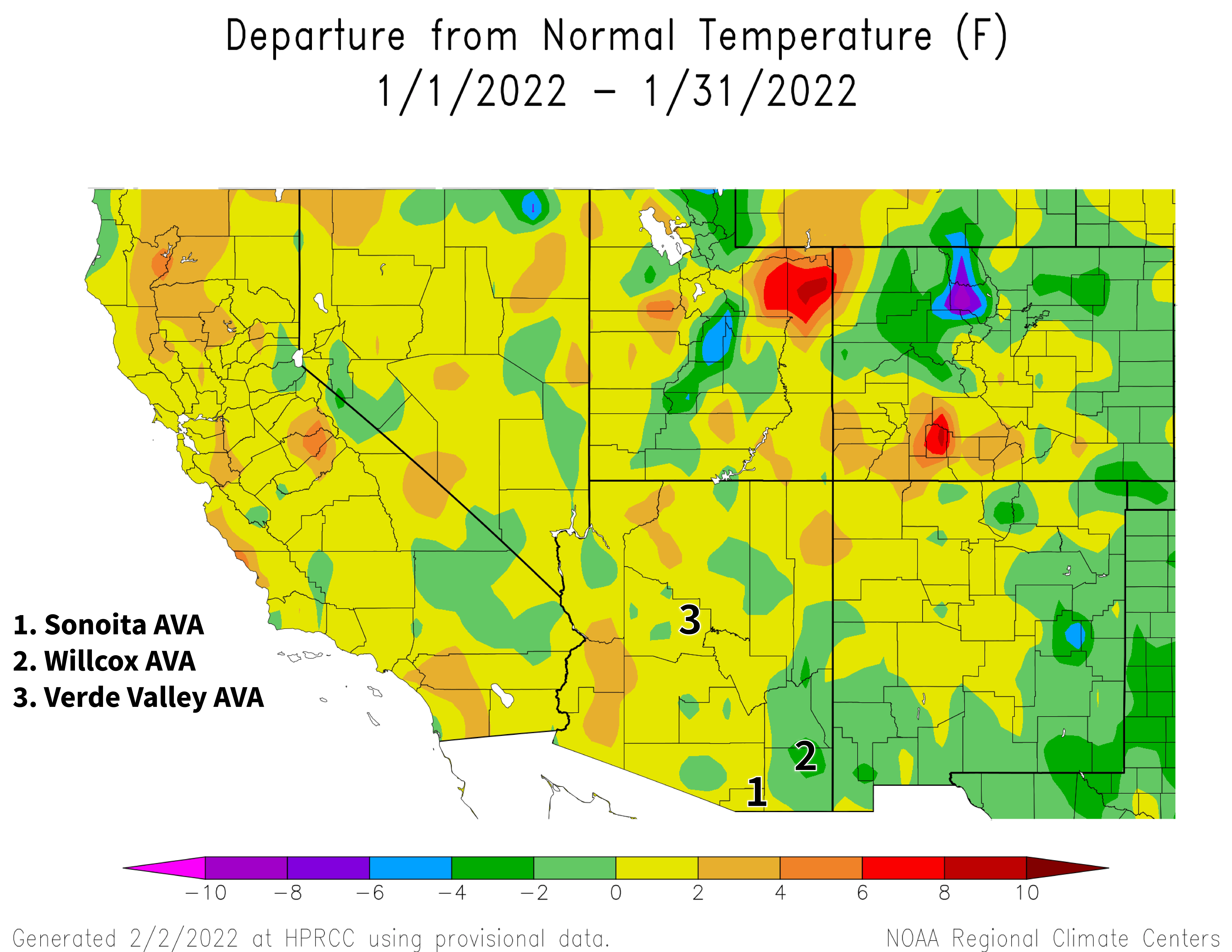
NOAA ACIS
Monthly precipitation totals were less than 50 % of the 1991-2020 normal for much of the state (dark orange, red, and dark red areas on map). For many growing locations in these areas, this converts to only a paltry 0.25 to 0.75 inches measured. Slightly more precipitation fell in a narrow swath across southeastern Arizona, where monthly totals were from 50 % to near normal (light orange and yellow areas on map). This contrasts with rain and snow amounts during January 2021, when precipitation was near or up to 200 % of the 1981-2010 normal for some areas in the southern and central part of the state, including the Sonoita, Verde Valley, and Willcox AVAs. Otherwise in Arizona last year, totals generally were below normal.
Combining January conditions with temperatures and precipitation totals from November and December may have walked us back from approaching the warm-and-dry extreme set in winter 2017-2018. However, we still are on the warm and dry sides of normal this dormant season, and still locked in to a La Niña event. More on both of these in following sections.
View more NOAA ACIS climate maps
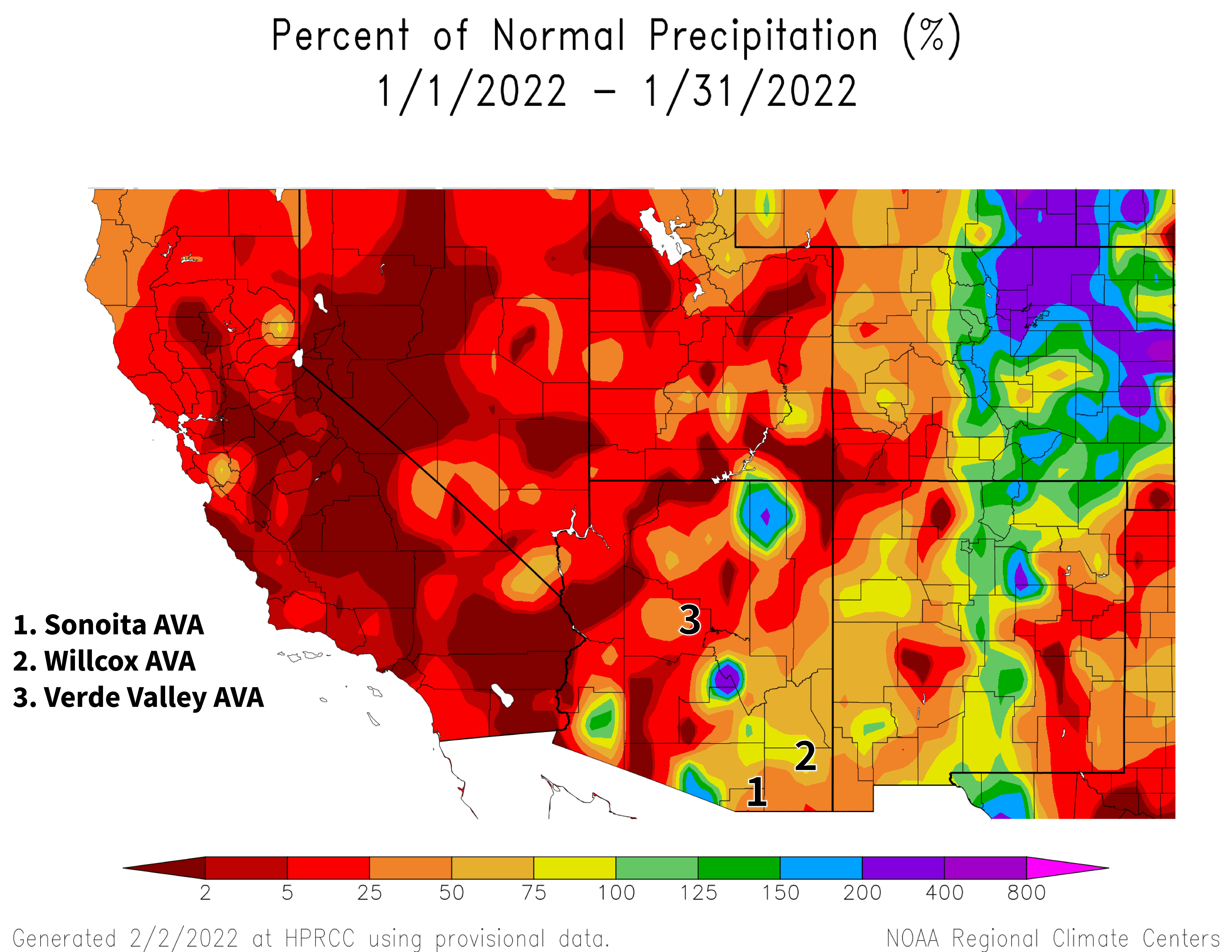
2022 January precipitation map
The Outlook for February Temperature and Precipitation
Temperatures over the course of this month have a slight increase in chances for being above the 1991-2020 normal across all of Arizona (orange area on map). For reference, monthly temperatures in February last year were within 3 °F of the 1981-2010 normal for almost all of the state.
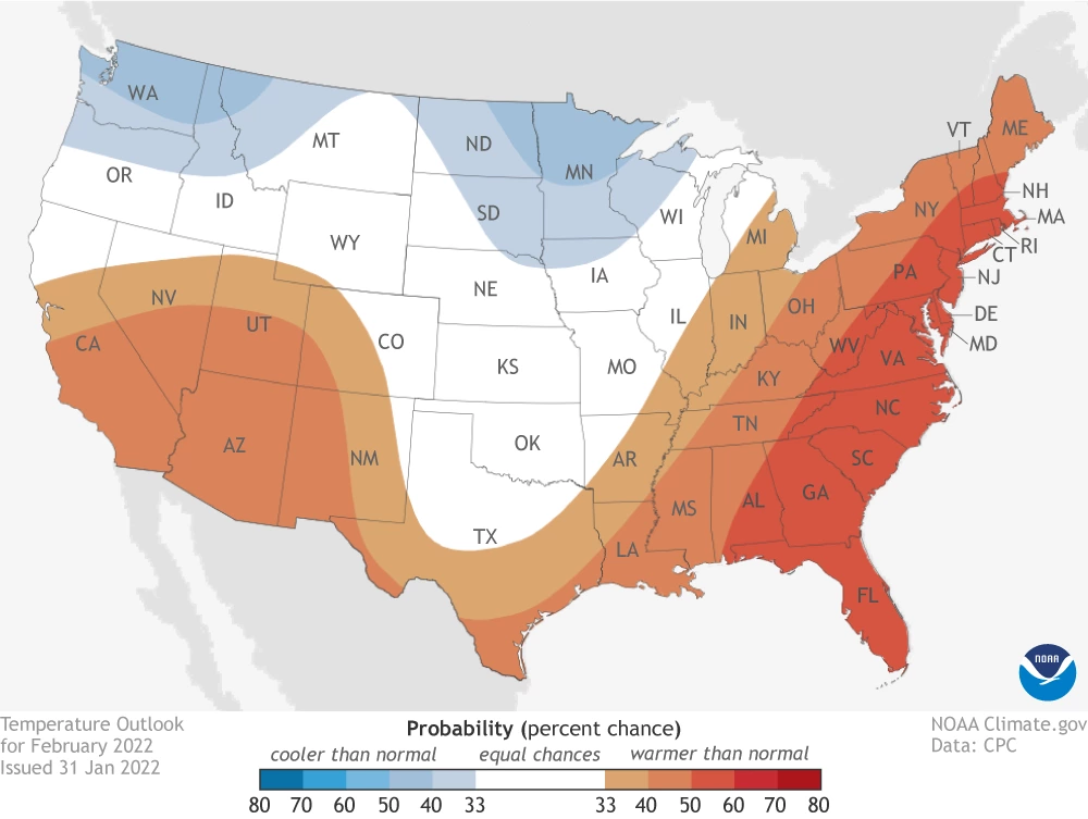
climate.gov
Precipitation totals for this month have a slight increase in chances for being below the 1991-2020 normal across almost all of the state (tan area on map). Precipitation during February 2021 was less than 50 % of the 1981-2010 normal for almost all of Arizona.
Due in part to La Niña conditions continuing to affect regional weather this dormant season, warm and dry conditions continue to be anticipated for the coming month. This doesn’t do much to change the storyline of winter irrigation being needed this year to prevent dry soil and delayed spring growth and to leach salts from the root zone.
Read more about the February 2022 temperature and precipitation outlook
To stay informed of long-range temperature and precipitation possibilities beyond the coverage of a standard weather forecast, check in, too, with the six-to-ten-day outlook and eight-to-fourteen-day outlook issued daily by NOAA’s Climate Prediction Center.
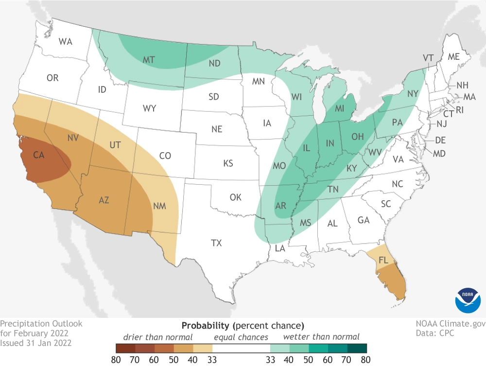
climate.gov
Seasonal Analogs for Arizona AVAs
As noted above, averaging temperatures and adding precipitation totals from January to those of November and December walked us back from approaching the warm-and-dry extreme set in winter 2017-2018 at each of the three Arizona AVAs. However, conditions this winter still are among the warmest and driest of the past 41 years.
Using the ‘analog’ approach from last month suggests that winter 2021-2022 (dark red dots on graphs) is, at this point in the dormant season, similar to winters 2008-2009 and 1995-1996 for all state AVAs (light red dots on graph). Other similar past winters are 2013-2014, 2005-2006, and 1981-1982 for the Sonoita AVA (top graph), 2020-2021, 2013-2014, and 2002-2003 for the Verde Valley AVA (middle graph), and 2002-2003, 1998-1999, and 1981-1982 for the Willcox AVA (bottom graph).
In addition to comparing general conditions from this winter to others as well as the 1991-2020 normals for temperature (thick gray vertical line in all graphs) and precipitation (thick gray horizontal line in all graphs), we’ll also start looking more specifically next month at chill and heat accumulation. Please let us know if these comparisons help you filter which past experiences might be most helpful in handling upcoming activities in the vineyard.
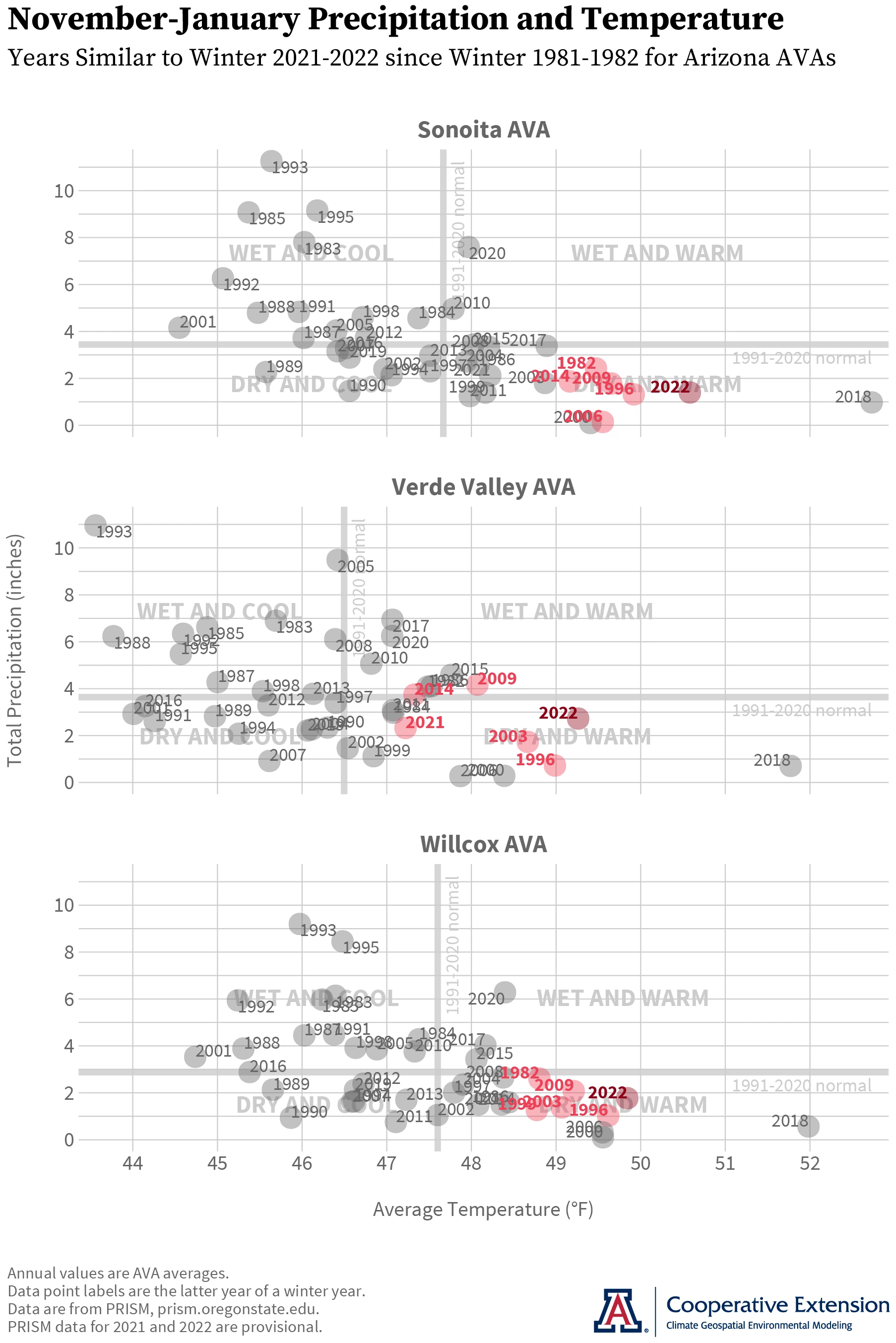
Jeremy Weiss
A Wrap-up on the 'Growing Season in Review' Workshops
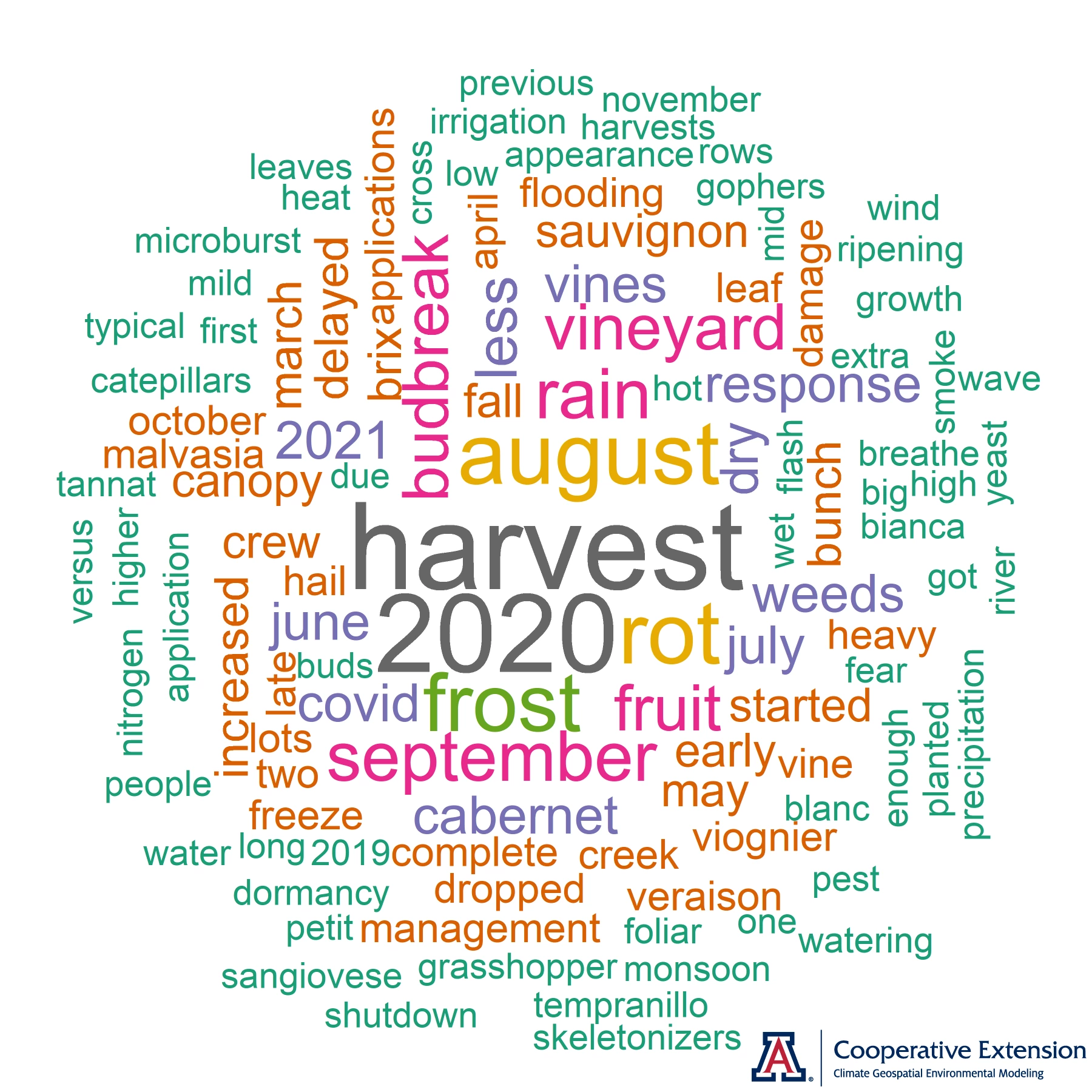
What were the topics on most minds at the 2021 ‘Growing Season in Review’ workshops for Arizona wine grape growers? The short answer to this question is this word cloud, in which the top terms are ‘harvest’, ‘2020’, ‘august’, ‘rot’, and ‘frost’. The long answer to the above question is our just-finished summary, where we take a closer look at these terms and some examples of them, along with a more general assessment of timeline posts.
Directly comparing the 2021 and 2020 growing seasons with workshop activities this year allowed participants to explore some uncharted territory. For during these two years, Arizona viticulture posted two new, more extreme endpoints in terms of conditions during the ripening and harvest periods. Many locations experienced near-record- to record-wet conditions in July and August in 2021 and near-record- to record-hot-and-dry conditions during those months in 2020. Heading into the workshops, we wondered if the extra rain or additional heat and drought these past two years led to intensified impacts or posed any novel challenges. Regardless of the answer to this question, we believe that experience gained in 2021 and 2020 will be especially valuable to growers as they address the more variable and extreme summer climate that is anticipated for the Southwest in coming years.
Jeremy Weiss
There now is a 67 % chance that the current La Niña event will persist into the March-to-May period. Once into the growing season, however, the ‘double-dip’ event of this winter is expected to fade away, as there is a 51 % chance of ENSO conditions transitioning to neutral between April and June. This is the most recent official forecast for ENSO, or El Niño Southern Oscillation, parts of the atmosphere and ocean across the tropical Pacific Ocean that cause El Niño and La Niña events.
For those of you in southeastern Arizona, Cooperative Extension manages an email listserv in coordination with the Tucson forecast office of the National Weather Service to provide information in the days leading up to agriculturally important events, like winter storms and cold-air outbreaks. Please contact us if you'd like to sign up.
And for those of you in north-central and northeastern Arizona, Cooperative Extension is starting to coordinate with the Flagstaff forecast office of the National Weather Service to soon provide a similar email listserv for those in agriculture in this part of the state. Please contact us if you'd like to sign up.
Undergraduate students in the College of Agriculture and Life Sciences at the University of Arizona are looking for internships with businesses and companies in the viticulture and winery industries during 2022. Please contact Danielle Buhrow, Senior Academic Advisor and Graduate Program Coordinator in the Department of Agricultural and Resource Economics, for more information.
Please feel free to give us feedback on this issue of the Climate Viticulture Newsletter, suggestions on what to include more or less often, and ideas for new topics.
Did someone forward you this newsletter? Please contact us to subscribe.
Have a wonderful February!
With current and past support from:
