< Back to Climate Viticulture Newsletter
Hello, everyone!
This is the 2019 June issue of the Climate Viticulture Newsletter – a quick look at some timely climate topics relevant to winegrape growing in Arizona and New Mexico.
A Recap of May Temperature and Precipitation
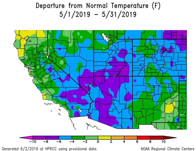
Monthly average temperatures in May were 4° to 10° Fahrenheit below normal for almost all of Arizona (blue and purple areas on map) and near to 6° Fahrenheit below normal across New Mexico (yellow, green, and blue areas on map). Along with these overall cooler-than-normal conditions, minimum temperatures on the 21st may have briefly dropped near or slightly below freezing in some winegrape-growing areas across southeastern Arizona where vines already were well into the growing season.
NOAA ACIS
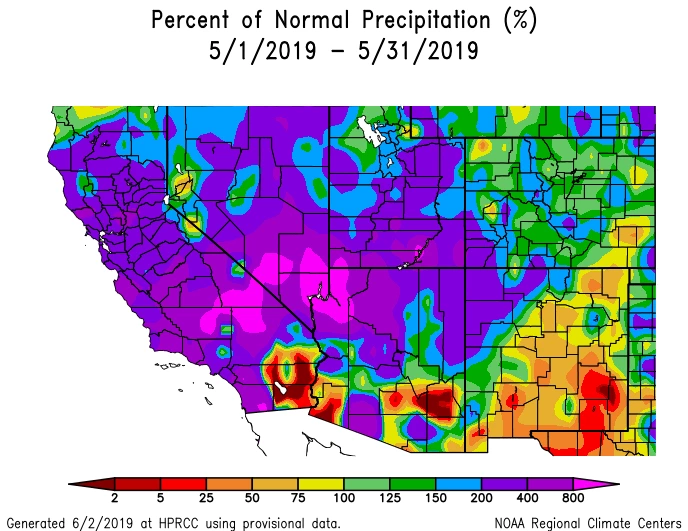
Monthly precipitation totals ranged from less than 25% of normal in southeastern New Mexico (red areas on map) to more than 400% of normal in northwestern Arizona (magenta areas on map). Hopefully, impacts from the unusually wet May across the latter part of the region remained on the positive side with benefits like increased soil moisture, and didn’t include any of the hail associated with some of the stronger storms.
NOAA ACIS
The Outlook for June Temperature and Precipitation
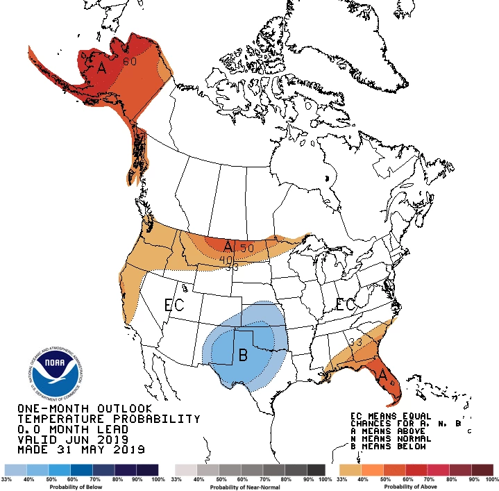
There is a slightly increased chance for below-average temperatures across the eastern two-thirds of New Mexico (blue areas on map). Equal chances for above-, near-, or below-normal temperatures exist for the rest of the region (white area on map). Like last month, temperatures potentially above average in some areas and below average in others might result in differences in the timing of and time between growth stages of a cultivar at different locations. Cooler temperatures can slow down vine phenology, whereas warmer temperatures can accelerate it.
NOAA CPC
There is a slightly increased chance for above-average precipitation across far northern Arizona and the western half of New Mexico, and an even greater chance across the eastern half of New Mexico (green areas on map). Equal chances for above-, near-, or below-average precipitation exist for the rest of the region (white area on map). For Arizona and the western half of New Mexico, however, June is a relatively dry month and above-normal rainfall totals could still amount to less than an inch for many areas, which means that irrigation savings could be minor. Nonetheless, let’s hope that any precipitation events that do occur will not bring about any hail, as some did last month.
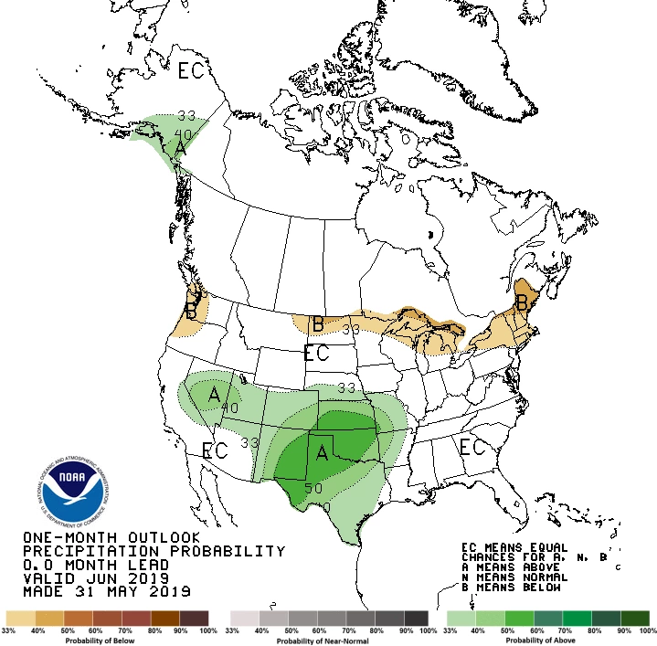
NOAA CPC
Heat Accumulation So Far This Year
A variable that helps us understand and predict the timing of vine growth stages is the accumulation of heat during the year, often quantified by the sum of growing degree days (GDDs).
As May was relatively cool for most of the region, we look to be starting June with accumulated GDDs that are a mix of mostly below- and near-average values across Arizona (blue, green, and yellow areas on map). In the Sonoita, Willcox, and proposed Verde Valley American Viticultural Areas (AVAs), for example, heat accumulations are below normal. In New Mexico, heat accumulations are slightly below, near, or slightly above average for much of the state (green, gray, and yellow areas on map).
Current accumulated GDDs appear to be lower than values from this time last year for several winegrape growing areas. We’d be interested in hearing from you if this has corresponded to different dates at which you have observed growth stages of your vines.
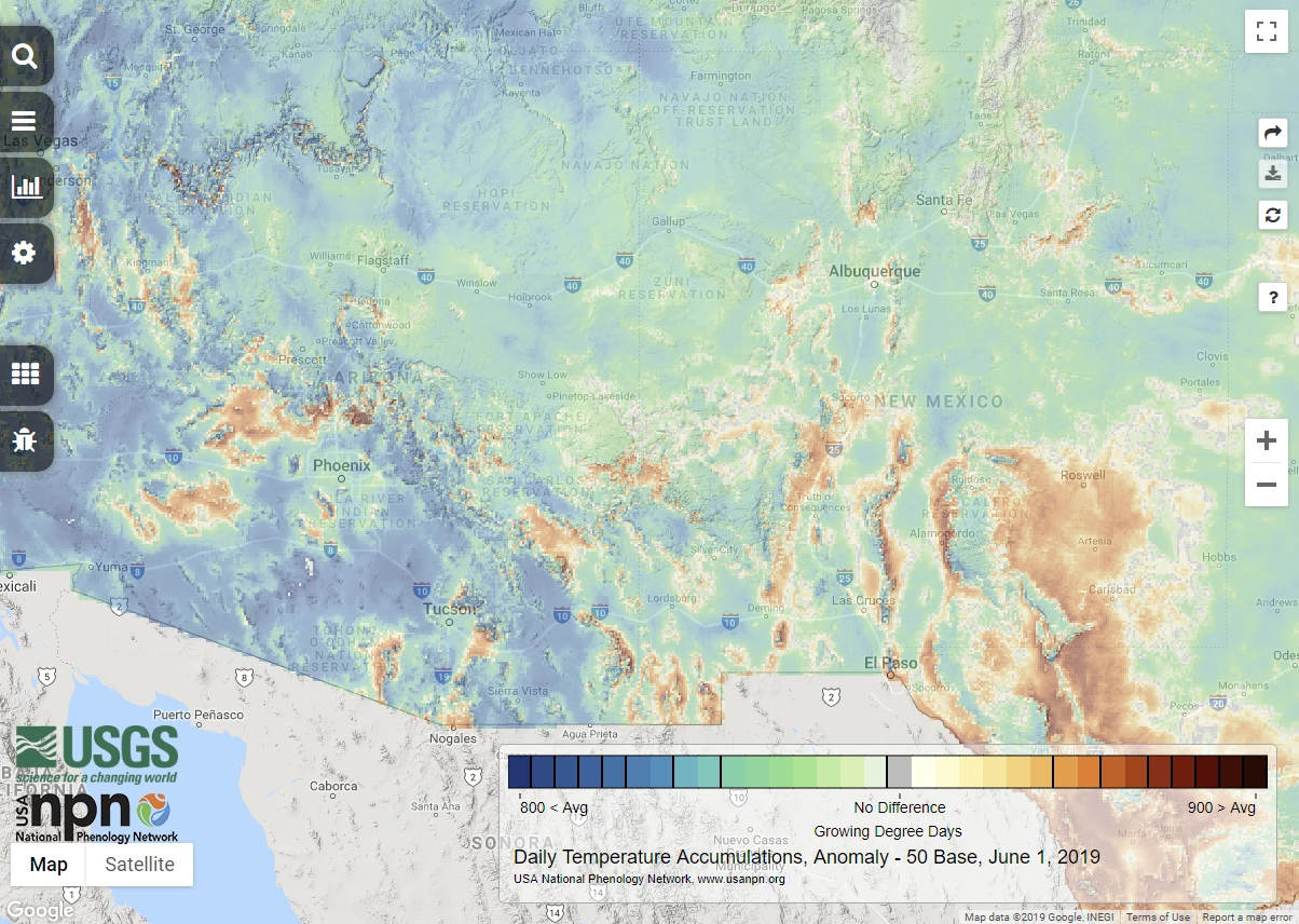
USGS NPN
'Tis the (Wildland Fire) Season
A lack of precipitation, warm temperatures, low humidity, and wind raise the potential for wildland fire by drying fine fuels – grasses, leaves, twigs, and shrubs – and making them easier to ignite and burn. Such hot and dry conditions across Arizona and New Mexico in June are part of the annual peak in wildland fire danger throughout the region. Smoke taint, which can eventually result in undesirable wine flavors and aromas, and displacement of insects from the burn area to a vineyard are two possible impacts to viticulture from wildland fire.
Like last month, there is a below-normal potential for significant wildland fires across northeastern Arizona and northern and eastern New Mexico (green area on map), and an above-normal potential across southern Arizona and the western part of the New Mexico ‘boot heel’ (red area on map). Otherwise, the potential for significant wildland fires in the region is near normal (white area on map).
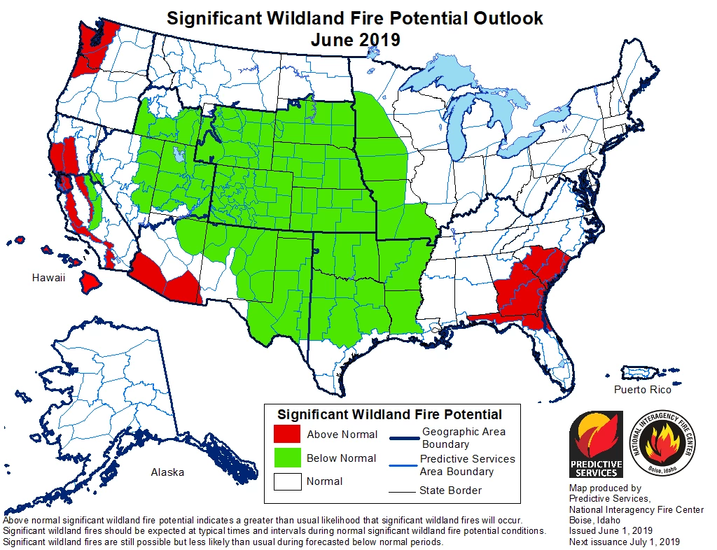
NICC NIFC
Now that it’s June, it’s time for many to begin thinking about the onset of the monsoon. One influence on the start of our summer rainy season is whether El Niño or La Niña conditions are present in the tropical Pacific Ocean. Currently, the relatively weak El Niño event that started in early 2019 continues and might help lead to a later monsoon start by inhibiting movement of moisture into the region.
Please feel free to give us feedback on this issue of the Climate Viticulture Newsletter, suggestions on what to include more or less often, and ideas for new topics.
Did someone forward you this newsletter? Please contact us to subscribe.
Have a wonderful June!
With support from:
