Using geospatial technologies to develop
participatory tools for natural resources management
![]() No. 53, May/June 2003
No. 53, May/June 2003
Using geospatial technologies to develop
participatory tools for natural resources management
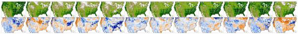
This is a time series of biweekly NDVI composite and a calculation of the Difference from Average NDVI from AVHRR satellite sensors for January to June 2003, for the contiguous US. This figure shows the concept of how such composite images work; on the actual RangeView web site, the images are animations that run like film strips that the user can control. |