Special issue: Selected papers from the IALC Conference:
Assessing Capabilities of Soil and Water Resources in Drylands:
The Role of Information Retrieval and Dissemination Technologies
Special issue: Selected papers from the IALC Conference: Assessing Capabilities of Soil and Water Resources in Drylands: The Role of Information Retrieval and Dissemination Technologies |
|
by Barbara Hutchinson
| "it is the hope of the ALIC staff that the ... issues presented [herein] will provide an appropriate framework to facilitate discussions and collaborations with other arid lands related entities, heading, ultimately, to the realization of a collaborative, international arid lands information system" |
Introduction(Back to top) The context for a global arid lands information system is closely related to the history of formalized arid lands research. At the University of Arizona, this focus began as early as 1891 with faculty publications on rangeland management and desert living issues. Soon after this, the Carnegie Institution established the Desert Botanical Laboratory in Tucson "for the purpose of ascertaining how plants perform their functions under the extraordinary conditions existing in the deserts" (McGinnies 1981, p.1). The Lab is currently affiliated with both the University of Arizona (UA) and the U.S. Geological Survey, and is still in operation, maintaining nearly 100-year-old study plots. Following WWII, interest in arid regions grew, culminating with UNESCO forming the Arid Zone Advisory Committee as the world's first attempt at a coordinated attack on the fundamental problems of living in arid and semi-arid regions. Building on this momentum, the American Association for the Advancement of Science took up the cause through a series of meetings organized by its Southwestern and Rocky Mountain Division. These began in 1955 in New Mexico with the University of Arizona playing a key role through the presence of a former president of the UA (Paylore 1985). Out of that particular meeting came the University of Arizona's determination to pull together a multidisciplinary approach for solving problems of aridity. Thus, in 1957, the University of Arizona president appointed an Arid Lands Research Advisory Committee "to consider the integration of ideas from all areas of the University and formulate programs designed to learn more about the problems and possible solutions to them" (Paylore 1985). This Committee prepared a report on the subject which became the basis for the program and which eventually was financed under a three-year grant from the Rockefeller Foundation in 1958. The results of the Committee's collaborative efforts led to another grant from the Army Research Office in 1963 to conduct the first comprehensive inventory of desert environments throughout the world. At $250,000, this was the largest grant the University of Arizona had received up to that time; it led to the creation of the Institute of Arid Lands Research, now named the Office of Arid Lands Studies (OALS). The Office of Arid Lands Studies(Back to top) The Arid Lands Information Center(Back to top) From the outset, ALIC staff has looked to technology to provide the tools needed to accomplish its mission: to organize, collect, and disseminate arid lands information as widely as possible and in the most cost-effective manner. Thirty years ago this involved a mainframe computer, punch cards, and rudimentary database programming to create the first Arid Lands Information System, or ALIS as it was called. Through this then state-of-the-art system, the first of an irregular Arid Lands Abstracts journal series was published. By the end of the 1970s, however, the costs for maintaining the system were prohibitive and other means were considered and evaluated. For a time, this led to an agreement with CAB International to cooperatively publish Arid Lands Development Abstracts - an effort that lasted from 1980-1982. Following this came the timely development of the desktop microcomputer. The continuing problem of maintaining the document collection and meeting outreach goals led the Center to purchase one of the first library-oriented database management systems (Micro-Cairs, produced by Leatherhead Industries in the United Kingdom), but when this system proved cumbersome, and much easier to use products became available, the Center quickly moved to a more friendly library system environment in the form of ProCite. For special libraries such as ALIC, these types of migrations from technology to technology are often a necessary fact of life. Thus, when the Internet became widely available, the staff recognized a new opportunity for cost-effectively reaching out to its clientele. The Internet and the World Wide Web have provided the foundation for pursuing a wide range of projects. Instead of operating as a solitary unit, as in the previous paradigm, a new project model emerged based on interdisciplinary and collaborative efforts. Now the Center operates as an information dissemination component for large multi-disciplinary efforts focused on diverse topics. This involves partnering with other departments and colleges, and collaborating with many different agencies and organizations. In most cases, the focus is on disseminating information in a way that can be useful for different levels of users. However, there is also a commitment to preserving information and data, facilitating access, and redesigning the data into practical decision-making tools. One example of this process is the Arid and Semi-Arid Watersheds web site developed in cooperation with the U.S. Forest Service (NB: addresses for web sites mentioned in this and the next paragraph are given at the end of this article). This site brings to the public 40 years of data collected as part of the Arizona Watershed Program, a project which began in the 1950s. Incorporated under an umbrella of general information about Western watersheds is a searchable database of watershed treatment data, including a GIS interface, which allows users to manipulate the data in new ways. Similarly, the Arizona Rangelands web site project incorporates many of these same characteristics. Begun as a component of the national Agriculture Network Information Center (AgNIC), the web site has grown into a western regional initiative involving 12 other states, and is the umbrella site for many related sub-projects that have developed specific information modules and tools. One is the database of Ecological Site Guides for Arizona that are used by the Natural Resources Conservation Service (NRCS) and other agencies for making land management decisions; another is a series of remote sensing tools for range management developed by the Arizona Remote Sensing Center through a NASA/Raytheon-funded program. An arid lands information system(Back to top) However, with the advent of the Internet and the World Wide Web, it was not long before the ALIC staff realized they now had the technologies necessary to bring the vision to reality. Formal internal discussions began to take place by the mid-1990s. This resulted in a draft document outlining a possible structure for an information system which was then called OASIS (Online Arid LandS Information Service). Over time, the concept became more refined, growing and developing in conjunction with staff skills in web site design, navigation, web-based databases, and portal technology. Although other web site developers laid claim to the original ALIS and OASIS names, the vision has stayed alive through the ensuing years and has gained momentum as new more dynamic web technologies have become available. A number of recent publications also speak to the merit of the concept for an international arid lands information system. They each address the need for improving access to information and tools related to the problems, opportunities, and issues of the world's arid environments. For instance, the World Bank's 2003 World Development Report targets challenges for improving livelihoods on fragile lands and for developing sustainable solutions for managing renewable natural resources. It even specifies the need to "invest in initiatives that...ensure systematic learning" (World Bank 2003). Similarly, the U.S. National Research Council recently prepared the report, Grand Challenges in Environmental Sciences (NRC 2001). Eight environmental targets were identified including biological diversity and ecosystem functioning, land-use dynamics, and climate variability - themes with particular relevance to those living in the marginal drylands of the world. The NRC recommended the establishment of research centers to support interdisciplinary research for the purpose of making science useful to decision-makers, managers, and the public. It also speaks to the need for international data harmonization. Another pertinent document is the GEO3 report, published by UNEP, but which involved many agencies in its compilation. One of the underlying needs identified as fundamental to action is a "greater provision of and access to information in all its forms as the fundamental basis of successful planning and decision-making" (UNEP 2002). Challenges include similar themes to the NRC and World Bank reports such as biodiversity threats, land degradation, human pressures on the land, and human vulnerability to environmental change. Given this history, and the information and research needs documented in these reports, the ALIC staff is reinitiating the idea for creating a comprehensive, value-added web resource focused on the world's arid regions. The purpose is not only to identify what already exists, but to fill knowledge gaps and to turn available resources into user-friendly tools. Also building on the successful model used for developing other web resources, an integrated approach would tie resources together under a single contextual umbrella. Such an initiative would draw on web portal technology and recognized standards to facilitate personalization of resources and to fully harmonize collaborative efforts. |
|
|
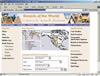
To visualize the entry point for such an information system, the ALIC staff designed a mock-up of a potential home page for a newly christened "Deserts of the World" web resource (Figure 1). This prototype includes a map interface which would link to extensive location-specific resources. A categorical search interface provides a dropdown list of topics covering many of the targeted issues outlined in the World Bank, NRC, and GEO3 documents, including human vulnerability, land degradation, and biological diversity and ecosystem functioning. These topics relate to the science and research aspects, whereas the applications listed in the right-hand column cover the more practical aspects. They are also repeated in the categorical search interface. Search options also include data type such as statistics, bibliographies, databases, and other tools. |
|
|
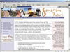
To demonstrate the extent of information and data to be included in the specific "desert" modules, a prototype section on the Sonoran Desert was developed (Figure 2). Major sub-topics include both human and physical aspects covering a variety of subjects such as urban and rural environments, recreation, agriculture, demographics as well as land degradation and pollution. The content for this module was developed by Professor Tina Kennedy from Northern Arizona University and while it is not complete, it already includes extensive synthesized information on the Sonoran Desert that was not previously available on the Web. Drawing on 2000 census data, a complete overview of the demographics of the region has been completed. In addition, much of the site is extensively documented with current photographs. The Sonoran Desert module is a work in progress, but it provides a model for developing additional desert modules. It is obvious that there are significant operational challenges if such an information system is to be fully developed. There are technical issues including interoperability and standards that need to be adhered to for data integration. There are accessibility issues in terms of design, navigation, and usability. There is the need to identify existing resources and information gaps and to fill those gaps with newly analyzed and synthesized information. Intellectual property and other legal issues also need to be considered, and it is necessary to consider how such a system could be managed and sustained over time. Finally, it seems clear that no one organization or institution can hope to accomplish all of these ends individually. To this end, it is the hope of the ALIC staff that the "Deserts of the World" prototype web site and the issues presented above will provide an appropriate framework to facilitate discussions and collaborations with other arid lands related entities, heading, ultimately, to the realization of a collaborative, international arid lands information system. References(Back to top) National Research Council, U.S. 2001. Grand challenges in environmental sciences. Washington, DC: National Academy of Sciences Press. Paylore, P. 1985. Arid lands commitments and legacies. Tucson, Arizona: University of Arizona, College of Agriculture, Office of Arid Lands Studies. UNEP 2002. Global Environment Outlook 3: Past, present and future perspectives. London: Earthscan Publications Ltd. World Bank. 2003. World Bank development report 2003: sustainable development in a dynamic world. Washington, D.C.: The World Bank. |
![]()
(Back to top)
Barbara Hutchinson, Director, Arid Lands Information Center, Office of Arid
Lands Studies, University of Arizona,1955 E. 6th St., Tucson, Arizona 85719-5224,
USA; Tel: 520-621-8578, Fax: 520-621-3816, Email: barbarah@ag.arizona.edu
(Back to top)
Arid and semi-arid watersheds web site
http://ag.arizona.edu/OALS/watershed/index.html
Arizona rangelands web site
http://rangelandswest.org/
Ecological site guides for Arizona
http://rangelandswest.org/az/siteguides/guides.html
Rangeview (remote sensing guides for range management)
http://rangeview.arizona.edu/
About the Arid Lands Newsletter