Using geospatial technologies to understand dryland dynamics
![]() No.
51, May/June 2002
No.
51, May/June 2002
Using geospatial technologies to understand dryland
dynamics
by Patricia C. Fanning and Simon J. Holdaway
|
"The artefact survey protocols we have developed for the drylands of western NSW, Australia, target land surfaces with the greatest potential for exposure of the archaeological record. (...) In effect, the artefact scatters have become 'time-averaged' deposits in which the products of many individual behaviors are now lumped together." |
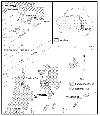
Background(Back to top) It has been very difficult for archaeologists in Australia to come to terms with the nature of this dispersed record. Archaeological work at Lake Mungo, in southwestern New South Wales (NSW), provides a good example. Nearly 30 years ago, Pleistocene dates from archaeological 'sites' in this region ensured that Lake Mungo became widely cited in archeology textbooks around the world. But a review of studies since then (Johnston and Clark 1998) shows that little published archaeological work has emerged. The chronology of the lakes has been progressively refined (e.g. Bowler and Price 1998, Gillespie 1998) but the archaeology has remained largely unknown because it was spread across areas measured in hectares rather than in a concentration buried at one small location (Shawcross 1998) and so was not easily definable in terms of sites. Dealing with large amounts of artefactual material, distributed across wide areas with no clear boundaries, presents both technical and theoretical challenges to a range of stakeholders who must deal with the archaeological record in the drylands (for example, national park managers, graziers, archaeologists, indigenous owners, infrastructure developers, and the tourism and mining industries). Management works best when bounded entities like sites can be clearly defined and located. It is much harder to manage the heritage value of sites where boundaries are not clear and may, in fact, vary through time as the conditions that promote surface exposure change. Here, we outline the ways in which geospatial technologies have been crucial in interpreting this record despite the difficulties imposed by the nature of the artefacts and their wide dispersal across the landscape. The approach we describe is based on fieldwork we have undertaken since 1995 in northwestern NSW, Australia, in Sturt National Park, and more recently at the Fowlers Gap Arid Zone Research Station north of the mining city of Broken Hill. In this project archaeological studies of artefact distribution are closely integrated with geomorphological studies of landsurface erosion and sedimentation, permitting interpretations to be developed for the many thousands of artefacts that lie exposed on the surface. The study area |
|
|
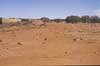
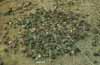
(Back to top) Surface stone artefact scatters: Why can we see them? |
|
|
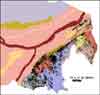
(Back to top) Rill and gully erosion has disturbed the integrity of part of this lag by moving some artefacts downslope, away from their original resting places (Holdaway et al. 1998). However, statistical analysis of relationships between artefact size and topographic factors demonstrates that, outside of the rills and gullies, little lateral disturbance can be detected (Fanning and Holdaway 2001a). The vertical integrity of the artefacts dropped by different groups of Aboriginal people occupying particular places in the landscape at different times has been lost, but rather than damaging the record, the process of erosion is a boon for archaeologists. Firstly, the erosion has 'excavated' areas two to three orders of magnitude larger than those commonly tackled by archaeologists who have to deal with buried deposits. The costs of excavation by conventional means preclude those deposits covering thousands of square meters, yet we know from studies of contemporary Aboriginal people who live in the arid zone that this is the size of the area over which camps sometimes extend (e.g. O'Connell 1987). There is every reason to expect that prehistoric camps were of a similar size, and reoccupation is likely to have extended the spatial distribution of artefacts beyond the limits of the original campsite. Secondly, the lagging process has conflated the discard products of many events together in one place. While this means that individual occupation events cannot be identified, it also means that patterns created through repeated occupations are much easier to study. Far from destroying the scientific potential of the archaeological record, the erosion-induced lagging process has greatly enhanced the ease with which this record can be observed. Applying geospatial technology to archaeological survey(Back to top) Since Land Systems are primarily defined by their topographic signature, using remotely sensed data (i.e. airborne and satellite imagery), those geomorphic and other environmental processes that affect artefact exposure and visibility are expected to vary more between Land Systems in a particular region than within any one of them. Therefore Land Systems maps provide a convenient means of assessing which parts of a region are most likely to exhibit maximum artefact exposure. At the second or meso-scale level, our survey method focuses on the smaller landform units and landform elements that make up Land Systems, as these reflect the operation of geomorphic processes over the contemporary to historic timescales. Standard aerial photograph interpretation and field survey methods are used to map landform elements and classify them on the basis of dominant geomorphic environment i.e. residual, transportational/eroding, fully lagged or depositional. In this way, the physical landscape is subdivided on the basis of both landform and dominant processes. The third or micro-scale level survey concentrates on documenting local variability in landsurface condition that reflects the operation of processes with a short time scale of perhaps hours to days. These landsurface conditions affect the archaeological record at the moment of survey. Such processes include local erosion and deposition of sediments, bioturbation, and vegetation growth. |
|
|
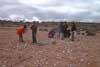
We use a vector GIS (ARCINFO/ARCVIEW) to integrate these three survey scales (Holdaway, Fanning and Witter 1997; Fanning and Holdaway submitted). Each of the three survey scales is mapped as a separate coverage in the GIS independent of the distribution of artefacts, which is also mapped as a separate coverage. Data tables hold descriptive information on the nature of each of the coverages. This format permits comparison of the interaction of the three survey scales with the distribution of artefacts. In addition, because of the relational format, data acquisition in the field at all three scales can progress independently. Three different approaches to artefact recording were also developed. In the first, aimed at relating artefact density and variability to landsurface type, the characteristics of every artefact larger than 20mm maximum dimension were recorded, together with their location in three-dimensional space. Once the raw data were converted to coverages in the GIS, the relationships between a variety of artefact characteristics and landsurface type could then be analyzed. In the second, within-unit artefact variability was examined by surveying all of the artefacts within just one landsurface type with high artefact exposure. Having determined the likely range of artefact types and densities from this intensive piece of proveniencing, systematic sampling techniques were applied to a much larger area. A grid of 1m x 1m squares oriented north-south and east-west was laid out, in which all the artefacts in every fifth square were recorded. This resulted in a 7% sample of the total area being recorded. |
|
|
Artefacts were recorded individually in the field and then replaced where they were found. A series of technological and typological variables were described for each piece. These included the nature of the evidence for flaking (flake, tool or core), the raw material type, the presence of cortex, the overall shape of the flake or core, the form of the tool and the number of retouched edges, and measurements of flake, tool and core size. These attributes were recorded into palmtop computers using data entry software (McPherron and Holdaway 1996) and transferred each day to the relational database and GIS. This system permits the rapid recording of large numbers of stone artefacts with only minimal disturbance of the surface record, honoring the wishes of indigenous custodians for their material cultural heritage to be left in place. Artefact visibility(Back to top) This has important implications for the definition of archaeological 'sites'. Despite the management utility of identifying small bounded entities, concentrations of artefacts (i.e. 'sites') when considered over small areas (tens or hundreds of square meters) occur for a variety of reasons. Our experience is that differentiating between the effects of surface condition, vegetation patterns and human behavior in the past can be very difficult in these situations. Only when areas of several thousands of square meters are considered in some detail does it become possible to understand what is causing artefacts to be concentrated. Spatial data collection technology has been essential to developing the methodology required to deal with this complexity. Developing behavioral interpretations of the artefacts(Back to top) Using these techniques to compare assemblages from different places within single field survey areas, we find that we are able to distinguish those places that were visited more often and perhaps for longer periods from those where visitation was less frequent and less prolonged. When extended to comparing assemblages from the broader geographic region of western NSW, these techniques can be used to differentiate and characterize variability in place use history between places with similar environmental and chronologic settings (Shiner et al. in preparation). Putting place use into a temporal framework(Back to top) The results of two sets of radiocarbon determinations obtained so far from ovens in western NSW challenge some commonly held views about Late Holocene Aboriginal occupation patterns. At Stud Creek near Mt Wood in Sturt National Park, 28 determinations returned ages between 220 and 1630 y BP. However, the spread of dates is discontinuous, with a 300 year gap between about 800 and 1100 y BP (Holdaway et al. 2002, Table 1), suggesting that this location may have been abandoned for a considerable period of time in prehistory. Further south, at Fowlers Gap, the age range is greater, extending to about 5000 y BP. However, it is not the time span of these dates that is of most interest, but the pattern of dates in relation to the inferred ages of the land surfaces on which the hearths and associated artifacts are found. On land surfaces where geomorphic processes of erosion and deposition are relatively active, such as the margins of modern stream channels, the dates are relatively recent and the record relatively short, reflecting the dynamic geomorphic environments at these locations. Sediments accumulate over short periods of time, perhaps a few hundred years, and are then removed by erosion during moderate flood events. In contrast, fine-grained alluvial drapes on low terrace surfaces are only geomorphically reworked during less frequent, high magnitude floods, and thus preserve a longer archaeological record. Furthermore, at each of the sampling locations at Fowlers Gap, the determinations form multiple clusters rather than a continuous sequence, a similar pattern to that found at Stud Creek. This suggests that Aboriginal people moved into and out of the region throughout the mid to late Holocene, occupying areas that had not been occupied for several centuries. This contrasts with the commonly held view from elsewhere in Australia that Aboriginal occupation of some regions was more or less continuous from the late Holocene onwards, reflecting increasing population and a more sedentary lifestyle. On the contrary, our research shows that Aboriginal hunter-gatherer groups remained relatively mobile, moving away from then back into previously occupied areas on a fairly regular basis throughout the mid to late Holocene and right up to the time of European contact around 150 years ago. |
|
|
These findings have implications for the application of conventional settlement pattern analyses based on site survey data. Surveys that do not take into account the geochronology of the surfaces on which 'sites' are located run the risk of combining archaeological materials with markedly different ages into a single settlement system. Geomorphological studies in other areas of Australia indicate that our findings are not likely to be unique. Summary: A new geoarchaeological framework for interpreting surface artefact scatters in the drylands(Back to top) Erosion of the fine sediments surrounding and supporting the stone artefacts has meant that the discard products of Aboriginal activity have been conflated. In effect, the artefact scatters have become 'time-averaged' deposits in which the products of many individual behaviors are now lumped together. By looking at the nature of the artefacts accumulated over time in different places in the landscape, archaeologists are able to distinguish those places that were used frequently from those that were used less often and those used for common activities from those used more sparingly. But, rather than seeking to date individual events, the goal is to seek pattern in both the spatial and temporal record of events that will allow a detailed prehistory of Aboriginal 'use of place' to be developed. References(Back to top) Christian, C.S. and G.A. Stewart.1953. General report on survey of Katherine-Darwin Region, 1946. Commonwealth Scientific and Industrial Research Organisation, Australian Land Research Service 1. Canberra: C.S.I.R.O. Fanning, P.C. 1994. Long-term contemporary erosion rates in an arid rangelands environment in western New South Wales, Australia. Journal of Arid Environments 28:173-187. Fanning, P. C. 1999. Recent landscape history in arid western New South Wales, Australia: a model for regional change. Geomorphology 29(3/4):191-209. Fanning, P.C. and S.J. Holdaway. 2001a. Stone artifact scatters in western NSW, Australia: Geomorphic controls on artifact size and distribution. Geoarchaeology: an International Journal 16(6):667-686. _____. 2001b. Temporal Limits to the archaeological record in arid western NSW, Australia: Lessons from OSL and radiocarbon dating of hearths and sediments. In Australasian Connections and New Directions: Proceedings of the 7th Australasian Archaeometry Conference, eds. M. Jones and P. Sheppard. Research in Anthropology and Linguistics 5:91-111. _____. Submitted but not published. Stone artifact exposure and visibility at open sites in western New South Wales, Australia: a geomorphic framework for survey and analysis. Paper submitted for publication 2002. Gillespie, R. 1998. Alternative timescales: A critical review of Willandra Lakes dating. Archaeology in Oceania 33:169-182. Holdaway, S., P. Fanning and D. Witter. 1997. GIS analysis of artefact distributions in an eroding landscape: the Western New South Wales Archaeological Project. In Archaeological Applications of GIS: Proceedings of Colloquium II, UISPP XIIIth Congress, Forli, Italy, September 1996. Johnson, I. and M. North, eds. Sydney University Archaeological Methods Series 5. Holdaway, S., D. Witter, P. Fanning, R. Musgrave, G. Cochrane, T. Doleman, S. Greenwood, D. Pigdon, and J. Reeves. 1998. New approaches to open site spatial archaeology in Sturt National Park, New South Wales, Australia. Archaeology in Oceania 33:1-19. Holdaway, S.J., P.C. Fanning, and D.C. Witter. 2000. Prehistoric Aboriginal occupation of the rangelands: Iinterpreting the surface archaeological record of far western New South Wales Australia. The Rangelands Journal 22:44-57. Holdaway S.J., P.C. Fanning, D.C. Witter, M. Jones, G. Nicholls and J. Shiner. 2002. Variability in the chronology of Late Holocene Aboriginal occupation on the arid margin of southeastern Australia. Journal of Archaeological Science 29:351-363. Holdaway, S.J. and J. Shiner. Submitted but not published. Hunter-gatherers and the archaeology of discard behaviour: an analysis of surface stone artefact scatters from Sturt National Park, western New South Wales, Australia. Paper submitted for publication 2002. Johnston, H. and P. Clark. 1998. Willandra Lakes archaeological investigations 1968-98. Archaeology in Oceania 33:105-119. McPherron, S. and S. Holdaway. 1996. Entrer Trois. In A Multimedia Companion to the Middle Palaeolithic Site of Combe-Cappelle Bas (France). H. Dibble and S. McPherron, eds. Philadelphia: University of Pennsylvania Museum. O'Connell, J. F. 198). Alyawara site structure and its archaeological implications. American Antiquity 52:74-108. Shawcross, W. 1998. Archaeological excavations at Mungo. Archaeology in Oceania 33:183-200. Shiner, J., S. J. Holdaway, H. Allen and P.C. Fanning. In preparation. Understanding stone artefact assemblage variation in late Holocene contexts in western New South Wales, Australia: Burkes Cave, Stud Creek and Fowlers Gap.
|
![]()
(Back to top)
Patricia Fanning is a Senior Lecturer in environmental science and management
in the Graduate School of the Environment at Macquarie University in Sydney,
Australia, where she has been teaching since 1990. Initially trained as a geomorphologist
specializing in erosion processes and landscape change in arid Australia, her
interests have extended to include geoarchaeology and cultural heritage management.
Mailing Address:
Graduate School of the Environment,
Macquarie University
NSW 2109
Australia.
Simon Holdaway is a Senior Lecturer in the Department of Anthropology at the
University of Auckland in Auckland, New Zealand. He received his Ph.D. from
the University of Pennsylvania (1991) dealing with the early Upper Paleolithic
of France. Since that time he has worked in Australia on the Holocene prehistory
of the arid zone and the Pleistocene prehistory of Tasmania. He has coauthored,
with Nicola Stern, a book on Australian prehistoric stone artifacts (Holdaway
and Stern in press).
Mailing Address:
Department of Anthropology
The University of Auckland
Private Bag 92019
Auckland 1
New Zealand.
(Back to top)
Western New South Wales Archaeology Program (WNSWAP)
http://www.gse.mq.edu.au/Research/wnswap/
The web site of the project described in this article.
Graduate School of the Environment, Macquarie University
http://handbook.mq.edu.au/p5/pt5f_135.htm
Department of Anthropology, University of Auckland
http://www.arts.auckland.ac.nz/ant/
About the Arid Lands Newsletter