Using geospatial technologies to understand dryland dynamics
![]() No. 51, May/June 2002
No. 51, May/June 2002
Using
geospatial technologies to understand dryland dynamics
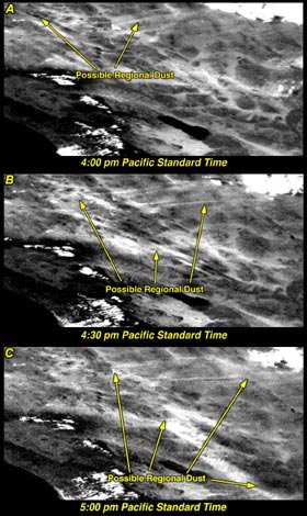 |
GOES images of the southwestern United States collected on April 23, 1997, when large dust plumes were generated by strong and very regional winds. Spatial resolution of the images is approximately 1 km and they were collected at 4:00 p.m. (A), 4:30 p.m. (B), and 5:00 p.m. (C). By combining images collected just 15 to 30 minutes apart for several hours, we can make a 'movie' showing relative dust concentrations, spatial distribution of the dust plume, and transport patterns of given dust plumes. |