Special issue: Selected papers from the IALC Conference:
Assessing Capabilities of Soil and Water Resources in Drylands:
The Role of Information Retrieval and Dissemination Technologies

Special issue: Selected papers from the IALC Conference: Assessing Capabilities of Soil and Water Resources in Drylands: The Role of Information Retrieval and Dissemination Technologies |
|
by Peter F. Ffolliott,
Jeffrey O. Dawson, James T. Fisher, Itshack Moshe,
Timothy E. Fulbright, Abdullah Al Musa, Carter Johnson, and Paul Verburg
| "Drylands are diverse in terms of their climate, soils, flora, fauna, land use, and people. No consistent characterization or practical definition of drylands can be made because of this diversity. One binding feature of all dryland environments, however, is their aridity." |
Introduction(Back to top) Aridity(Back to top) Aridity can be expressed in a number of ways as a function of rainfall and temperature. One common representation of aridity is the index used by the United Nations Educational, Scientific and Cultural Organization (UNESCO), expressed as the ratio of average annual precipitation to average potential evapotranspiration, the latter being calculated by Penman's method, taking into account atmospheric humidity, solar radiation, and wind (Baumer and Salem 1985). That is,
Three bioclimatical zones of high aridity are delineated by this index: hyperarid (<0.03), arid (0.03-<0.20), and semiarid (0.20-<0.50). Of the total land area in the world, hyperarid zones cover 4.2%, arid zones 14.6%, and semiarid zones 12.2%. Hyperarid zones are regions where annual rainfall is low, rarely exceeding 100 mm. Rainfall is infrequent and irregular, with sometimes no rain for several years. Sparse annual and perennial vegetation and scattered shrubs feature the landscape. True nomadic pastoralism is frequently practiced. Arid zones are characterized by high rainfall variability, with annual amounts generally ranging between 100 and 300 mm. Vegetation is sparse, comprised of annual and perennial grasses, other herbaceous plants, shrubs, and small trees. Extensive and often nomadic pastoralism is found and there is little farming except where irrigation is possible. Annual rainfall in semiarid zones varies from 300 to 800 mm, depending on the relative occurrences of summer and winter rains. Native vegetation includes a variety of grasses and grass-like plants, forbs and half-shrubs, and shrubs and trees. Rain-fed sustained levels of agricultural production is often supported. Sedentary livestock production also occurs. These three bioclimatical zones, together with their surrounding sub-humid margins (0.50-<0.75), comprise the dryland regions of the world. |
|
|
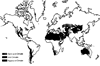
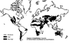
Large areas of drylands are located in North and South America, North Africa, the Sahelian region, Africa South of the Equator, the Near East, and the Asia and the Pacific regions (Figure 1). More specifically, hyperarid zones are located in Saharan Africa, northern and southeastern Saudi Arabia, Ethiopia, and Namibia. Arid and semiarid zones are more widespread, although there is a tendency for them to be found toward the western edges of tropical and sub-tropical areas of the continental masses, a feature that is particularly marked in southern Africa, the Americas, the Indian sub-continent, and, to some extent, Australia. Climate(Back to top) |
|
|
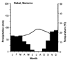
Dryland environments are characterized generally by inadequate and variable rainfall. Some of these environments have excessive heat while others are cold areas. However, large contrasts in climate occur, such as that found in Tibet and Mongolia. Three major types of climate - Mediterranean, Tropical, and Continental - are found in the drylands of the world. Rainy seasons in a Mediterranean climate normally occur in autumn and winter (Figure 2a). Summers are hot with little or no rain, while winter temperatures are relatively mild. Rainfall occurs during the summer in areas typical of a Tropical climate (Figure 2b). The greater the distance from the equator, the shorter the rainy season is. Winters are long and dry. Rainfall is distributed more or less evenly throughout the year in a Continental climate, although there is a tendency toward greater summer rainfall (Figure 2c). Summers are hot while winters are comparatively cold. |
|
|
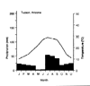
Modifications of the three major types of climate are found throughout dryland environments. For example, two rainfall periods occur in Tucson, Arizona, one in the hot summer and another in the cool winter (Figure 3). Although total annual rainfall is frequently less than 300 mm, its distribution into two seasons partly explains the relatively dense cover of small trees, shrubs, and other herbaceous species which is common to the Sonoran Desert of northern Mexico and the southwestern United States. Rainfall variability and the occurrence of prolonged periods of droughts are a characteristic of dryland regions that must be recognized in the planning and management of natural and agricultural resources (Jackson 1989). Over two-thirds of Africa receives annual rainfall during three months and there are large variations in the amount of annual rainfall that occur. The maximum annual rainfall recorded in Liberia is 1,203 mm, the minimum is 123 mm, and the average is 461 mm. At Meru, Kenya, rainfall amounts in October have ranged from as little as 15 mm to as much as 1,386 mm. Even in the most arid areas, rainfall can be quite variable. The average annual rainfall at the Red Sea station of Hurghada is only 8 mm. In November 1991, however, 41 mm of rain fell in one day. While more examples could be presented, the point made is that average values of seasonal or annual rainfall do not necessarily provide a representative picture of the climatological conditions for many dryland regions. Rainfall intensity is another parameter that must be considered in planning and management of natural resources. Because the soils of dryland environments often cannot absorb all of the rain that falls in large storms, water is often lost from a site by runoff processes (Brooks et al. 1997). At the opposite extreme of the spectrum, water from a rainfall of low intensity can be lost through evaporation when the rain falls on a dry soil surface. Rainfall intensity also relates to the risk of soil erosion. Individual rain drops carry enough energy to be capable of removing topsoil upon impact, causing splash erosion which can degrade or destroy the soil structure through time. Dryland environments are frequently characterized by a relatively cool and dry season, followed by a relatively hot and dry season, and, finally, by a moderate and rainy season. There are often significant diurnal fluctuations in temperatures that restrict the growth of plants within these seasons. Plant growth takes place between species-specific maximum and minimum temperatures. Extremely high or low temperatures can be damaging to plants. Plants might survive high temperatures if they can compensate for these high temperatures by transpiration, but their growth rates can be affected negatively. High temperatures at the surface layer of the soil result in a rapid loss of soil moisture because of the high evaporation and transpiration rates. While problems of low temperature are generally less common in dryland environments, when they occur over relatively long periods of time, plant growth can be restricted. Plants die at prolonged temperatures below 0° C. Atmospheric moisture Atmospheric moisture (humidity) has importance to the water balance of a soil body. There is a tendency for water to evaporate into the atmosphere when the moisture content of the soil is higher than the air. When the opposite is the case, water will condense into the soil. Atmospheric humidity is generally low in dryland environments. Occasional occurrences of dew or mist along large water bodies can lead to higher humidity in the air than otherwise expected and, therefore, reduce evapotranspiration and conserve soil moisture. Wind Dryland environments are typically windy, largely because of the scarcity of vegetation and other obstacles that can reduce air movements. Wind moves the moist air that surrounds plants and soil bodies and, as a consequence, decreases atmospheric moisture and increases evapotranspiration rates. Some plants inherently transpire less than other plants and, therefore, are adapted to dry environments. Dust storms are also frequent when little or no rain falls. Soil erosion by wind occurs whenever the soil, vegetation, and climatic conditions are conductive to this kind of erosion. These conditions are encountered in environments with loose, dry, and fine soil, a smooth ground surface, a sparse vegetative cover, and sufficiently strong wind to initiate soil movement. Among the more damaging impacts resulting with wind-blown soil particles is the sorting out of the soil material. Erosion by wind gradually removes silt, clay, and organic material from the soil surface, with the remaining materials being sandy and infertile. The residual sand that piles up in dunes on some landscapes presents a threat to the surrounding lands. Drought(Back to top) It is known that droughts will likely occur in the future, but it is not possible to reliably predict when they will occur, their severity, or how long they will last. Because of the uncertainties associated with drought and the severity of the impacts, there are many considerations about drought that must be taken into account in planning and management of natural and agricultural resources in drought-prone regions. Drought is generally characterized by shortages of water, food for people, and forage for livestock that can lead to unplanned and often unwise use of available agricultural and natural resources (Sidebar 1). Serious degradation of land and resources can result if contingency planning is not undertaken to meet these shortages. Geomorphology(Back to top) Soils(Back to top) Of primary importance to planners and managers of natural and agricultural resources are the water-holding capacity of these soils and their ability to supply nutrients. Soil depth and texture largely governs the amount of water that can be held in a soil body. However, the depth of soils in dryland regions is often limited by a hardpan layer, restricting water-holding capacities and rooting depth. These hardpans, often consisting of CaCO3 or silicaceous materials, can be more or less continuous and occur between 5 and 60 cm below the surface. As there is little deposition, accumulation, or decomposition of organic material in dryland environments, the organic content of the soils is low and, therefore, natural soil fertility is also low. The limited organic matter that is present can be quickly lost when soils are cultivated for agricultural crop production. Soils are often characterized by the extensive leaching of nutrients and intensive weathering of minerals on older exposed surfaces. Water resources(Back to top) Water that is available for use in many drylands regions can be affected by salinity. Problems of salinity are more widespread and acute in the drylands than other regions (Armitage 1987). Although most soil bodies contain some soluble salts, it is only when the accumulations of salts attain a level that is harmful to plant survival and growth that a saline condition has developed. In effect, therefore, plants "define" the salinity of soil in terms of their relative tolerances. Mineralization of groundwater resources is also a common problem. The causes of mineralization include the evaporation from water surfaces and shallow groundwater, fossil brines from ancient lagoons and lakes, and airborne salts deposited by precipitation and in the form of dry fallout. Vegetation(Back to top) Three plant forms - ephemeral annuals, succulent perennials, and non-succulent perennials - are found in dryland environments. Ephemeral annuals appear after rains and complete their life cycle during a short season (8 weeks). Ephemerals are small in size, have shallow roots and, at times, form relatively dense stands and provide some forage. Succulent perennials store water through the enlargement of parenchymal tissue, thereby reducing transpiration rates. This water can then be consumed in periods of drought. Cacti are typical succulent perennials. Non-succulent perennials that withstand the stress of dryland environments are the majority of plants in these regions. Three forms of non-succulent perennials - evergreen, drought-deciduous, and cold-deciduous - are found in the drylands. Evergreen plants are active biologically throughout the year, drought-deciduous plants are dormant in the dry season, and cold-deciduous plants are dormant in the cold season. Adaptive attributes Many plants have adaptations which enable them to reproduce, survive, and grow in some of the harshest environments in the world. The extremes of dryland climates largely dictate the form of the physiological adaptations and ecological requirements of plants in these regions. Xeromorphological leaf structures, physiological controls of transpiration and metabolism rates, moisture and nutrient storage organs, and thorns are common features. Such specializations become less pronounced as aridity becomes less severe and the conditions for plant establishment and growth become favorable. At the more "arid end" of the dryland environmental spectrum, only a few of the specially adapted plants provide food for people or livestock, although leaves and flowers of some plants are useful as supplements. Some plants have evolved specialized rooting systems, while others have unique leaf characteristics that allow them to withstand prolonged periods of drought through a reduction in transpiring surfaces (Sidebar 2). Other plants simply lose their leaves when soil moisture conditions become too dry. Cuticularization, the formation of surface plaster-like layers of cutin; cutinazation, the impregnation of cell walls with cutin to form a water-tight layer; and special arrangements of stomata in recesses and grooves to provide protection from the dry atmosphere are other xerophytic characteristics of these plants. Wildlife(Back to top) Species of indigenous wildlife inhabiting dryland regions often have physiological and ecological advantages in relation to livestock. Among the more significant of these advantages are their abilities to thrive without an abundance of surface water by their movements in time and space, their use of the sparse vegetation for food and cover, and their minimal impacts on the environment when their populations are balanced properly with the environment (Heady and Heady 1982; Child 1989; Ffolliott et al. 1995). Many of these wildlife species possess attributes of disease, heat, and drought tolerance, and reproductive and meat production characteristics that are generally more efficient than livestock. Uses of wildlife resources Principal ways in which the wildlife resources are used by people include cropping for meat, skins, and trophies, and viewing and photography by tourists (Heady and Heady 1982; Child 1989). The meat of wildlife is often a source of food for pastoralists and agricultural cultivators of marginal lands in times of drought. It is likely that the importance of wildlife for meat will increase in many countries in the future as the carrying capacities for livestock continue to decline because of overgrazing. Harvesting of wildlife for skins and trophies in many countries is driven mainly by needs for increased incomes, and, as a consequence, populations can be decimated without regard to more sustainable wildlife values. Cropping of wildlife is a form of use on relatively open lands that are not sanctuaries, while viewing and photography are more prevalent in natural parks and reserves where concentrations of wildlife can be seen. Land use(Back to top) Combinations of agricultural cropping, livestock production, forestry, and other types of production systems are frequently placed on the same piece of lands, either rotationally, simultaneously, or spatially on the same piece of lands. Regardless of the nature of these combinations, attaining ecological stability and sustainable benefits to users of the land is the goal. Combined production systems that include trees or shrubs are known more commonly as agroforestry systems (Nair 1989; Gordon and Newman 1997; Buck, Lassoie and Fernandes 1999). Historically, it has been a common practice for rural people living in the dryland regions to cultivate agricultural crops and tree or shrubs in intimate combinations (Sidebar 3). Agroforestry is recognized by professional and lay stakeholders as a set of systems, practices, and technologies that are capable of yielding food and wood while conserving resources and, when necessary, rehabilitating ecosystems. Consumptive and non-consumptive uses of wildlife resources, recreational activities and tourism, and amenity plantations of trees and shrubs are also important components in many efforts to attain conservation and sustainable use of dryland systems. Although it is not always possible to place monetary values on these components, they frequently make economically significant contributions to overall developmental activities and the general well-being of local people. It is necessary, therefore, to consider the varied roles that wildlife, recreation and tourism, and amenity plantations play in dryland regions when addressing issues related to land use. People(Back to top) Rural people living in drylands are arranged roughly into nomadic, seminomadic, transhumant, and sedentary populations. Nomadic people are found in pastoral groups which depend on livestock for subsistence and, whenever possible, farming as a supplement. Following the irregular distribution of rainfall, they migrate in search of pastures and water for their animals. Seminomadic people are also found in pastoral groups which depend largely on livestock and practice agricultural cultivation at a base camp, where they return for varying periods of time. Transhumant populations combine farming and livestock production during favorable seasons, but seasonally they might migrate along regular routes when forage for grazing diminishes in the farming area. Sedentary farmers practice rainfed or irrigated agriculture. Land use practices are often a form of agroforestry in structure and function. There is often little distinction between a farmer and a pastoralist. People living in dryland environments generally take into account the limitations of the local conditions they confront and adopt to whatever land use is suitable and feasible in seeking their livelihood. However, the delicate balance that is achieved through traditional forms of farming and livestock production is easily upset; this is shown by a general deterioration of grazing lands in dryland regions. A main cause of this deterioration - often referred to as desertification in its most severe form - is the over-population of people and their livestock, where agricultural cropping and pastoralism become competitive rather than complementary forms of land use. Desertification |
|
|
(Back to top) The United Nations Environment Program (UNEP) has estimated that 35 million km2 of the dryland regions of the world, an area approximately the size of both North and South America, are affected by desertification or the threat of desertification (FAO 1989b; UNEP 1992). Nearly 25 million km2 of this area has been classified as exposed to either high and very high desertification risk. Equally important is the fact that 30,000 km2 are reduced to a state of "uselessness" every year, a loss that is expected to continue into the future unless remedial actions are taken. Destruction of the impacted lands' productive capacity brought about by desertification costs the world more than $75 billion each year. The multitude of problems that constitute desertification defy a single solution. The magical "magic bullet" does not exist nor is it realistic to expect that it will ever exist (Mouat, Hutchinson and McClure 1995). Physical, biological, and economic and other social factors causing desertification vary so widely and are found in such a bewildering array of combinations that most of the "formula-based solutions" for dealing with the issues of desertification are incomplete and insufficient. Desertification control and the related resource development is likely more a social activity than a technical one. Desertification, therefore, is largely a problem for people to mitigate. Concluding comments(Back to top) The drylands of the world also suffer from the vicious cycle of low productivity, low levels of investment, and, as a result, poverty. Investments, apart from those made for irrigated agriculture activities, are relatively low (Marples 1986, Ffolliott et al. 1995, Squires and Sidahmed 1998). Low productivity, low levels of investment, and land degradation often leading to desertification are responsible for regional poverty and income disparities. The poverty and hunger that are prevalent in sub-Saharan Africa are a poignant example of this situation. Other critical problems include the inherent problems of water scarcity, tenure considerations, and ineffective developmental policies. Improving this situation requires that a variety of technical and institutional problems be solved. Among these solutions is increasing the level of investments in appropriate agriculture, alternative land use practices, and other appropriate income-generating interventions. Other solutions are designing strategies for risk management and implementing programs for more equitable land distribution and levels of income. References(Back to top) Baumer, M. C., and B. B. Salem. 1985. The arid zone. In Sand dune stabilization, shelterbelts and afforestation, 1-8. FAO Conservation Guide 10. Rome: FAO. Brooks, K. N., P. F. Ffolliott, H. M. Gregersen, and L. F. DeBano. 1997. Hydrology and the management of watersheds. Ames, Iowa: Iowa State University Press. Buck, L. E., J. P. Lassoie, and E. C. M. Fernandes, eds. 1999. Agroforestry in sustainable agricultural systems. Boca Raton, Florida: Lewis. Child, G. S. 1989. Utilization of wildlife. In Role of forestry in combating desertification, 173-182. FAO Conservation Guide 21. Rome: FAO. Dregne, H. E. 1983. Desertification in arid lands. New York: Harwood. El-Baz, F. 1991. Desertification. Geotimes 36(2):52-54. FAO. 1989a. Arid zone forestry: A guide for field technicians. FAO Conservation Guide 20. Rome: FAO. FAO. 1989b. Role of forestry in combating desertification. FAO Conservation Guide 21. Rome: FAO. Ffolliott, P. F., K. N. Brooks, and M. M. Fogel. 2002. Managing watersheds for sustaining agriculture and natural resource benefits into the future. Quarterly Journal of International Agriculture 41(1/2):23-40. Ffolliott, P. F., K. N. Brooks, H. M. Gregersen, and A. L. Lundgren. 1995. Dryland forestry: Planning and management. New York: John Wiley & Sons. Gordon, A. M., and S. N. Newman, eds. 1997. Temperate agroforestry systems. London: CAB International. Guttman, N. B. 1998. Comparing the Palmer drought index and the standardized precipitation index. Journal of the American Water Resources Association 34:113-121. Heady, H. F., and E. B. Heady. 1982. Range and wildlife management in the tropics. New York: Longman. Heathcote, R. L. 1983. The arid lands: Their use and abuse. London: Longman. Hocking, D. 1987. Acacia albida - the farmers choice for semi-arid and arid zones. Nitrogen Fixing Tree Association NFT Highlights 98-02, Waimanalo, Hawaii, USA. Jackson, I. J. 1989. Climate, water and agriculture in the tropics. Singapore: Longman. Joffre, R., J. Vacher, C. Los Llanos, and G. Long. 1989. The Dehesa: An agrosilvipastoral system of the Mediterranean region with special reference to the Sierra Morena area of Spain. In Agroforestry systems in the tropics, ed. P.K.R. Nair, 427-453. Dordrecht, the Netherlands: Kluwer. Lohani, V. K., and G. V. Longanathan. 1997. An early warning system for drought management using the Palmer drought index. Journal of the American Water Resources Association 33:1375-1386. Maranon, T. 1988. Agrosylvopastoral systems in the Iberian peninsula: Dehesas and Montados. Rangelands 10:255-258. Marples, S. 1986. Production and investment in marginal areas. In Development of rainfed agriculture under arid and semiarid conditions, ed. T.J. Davis, 87. Washington, DC: The World Bank. McKee, T. B., N. J. Doeskin, and J. Kleist. 1993. The relationship of drought frequency and duration to time scales. In: Proceedings of the 8th conference on applied climatology. American Meteorological Society, Boston, Massachusetts, USA, pp. 179-184. McKee, T. B., N. J. Doeskin, and J. Kleist. 1998. Drought monitoring with multiple time scales. In Proceedings of the 9th conference on applied climatology, 233-236. Boston: American Meteorological Society. Mouat, D. A., C. F. Hutchinson, and B. C. McClure. 1995. Introduction. In Desertification in developed countries, eds. D.A. Mouat and C.F. Hutchinson, 1-4. Dordrecht, the Netherlands: Kluwer. Nair, P. K. R., editor. 1989. Agroforestry systems in the tropics. Dordrecht, the Netherlands: Kluwer. Palmer, W. C. 1965. Meteorological drought. U.S. Weather Bureau, Research Paper 45. Washington, DC: U.S. Weather Bureau. Persaud, N., S. Long, M. Gandah, and M. Ouattara. 1986. Influence of wood-harvesting method on wind protection between rows of neem (Azadirachta indica) plantation in Niger, West Africa. In International symposium on windbreak technology, eds. D.L. Hintz and J.R. Brandle, 211-212. Great Plains Agricultural Council Publication 117. Squires, V. R., and A. E. Sidahmed. 1998. Drylands: Sustainable use of rangelands into the twenty-first century. Rome: International Fund for Agricultural Development. United Nations. 1977. Desertification: Its causes and consequences. London: Pergamon. UNEP. 1992. World atlas of desertification. London: Edward Arnold. Went, F. W. 1955. The ecology of desert plants. Scientific American 192(4):68-75. White, R. P., D. Tunstall, and N. Henninger. 2002. An ecosystem approach to drylands: Building support for new development policies. Information Policy Brief 1. Washington, DC: World Resources Institute. |
![]()
(Back to top)
Peter F. Ffolliott, Professor, School of Renewable Natural Resources, University
of Arizona, Tucson, Arizona 875721, USA
Jeffrey O. Dawson, Professor, Department of Natural Resources and Environmental Sciences, University of Illinois, Urbana, Illinois 61801, USA
James T. Fisher, Professor and Head, Department of Agronomy and Horticulture, New Mexico State University, Las Cruces, New Mexico 88003, USA
Itshack Moshe, Deputy Director, Southern Region, Land Development Authority, Gilat DN Negev 85410, Israel
Timothy E. Fulbright, Regents Professor, Caesar Kleberg Wildlife Research Institute, Texas A&M University-Kingsville, Texas 78363, USA
Abdullah Al Musa, President, University of Jordan, Amman 11195, Jordan
Carter Johnson, Professor, Department of Horticulture, Forest, Landscape and Parks, South Dakota State University, Brookings, South Dakota 57007, USA
Paul Verburg, Assistant Research Professor, Division of Earth and Ecosystem Sciences, Desert Research Institute, Reno, Nevada 89512, USA
About the Arid Lands Newsletter