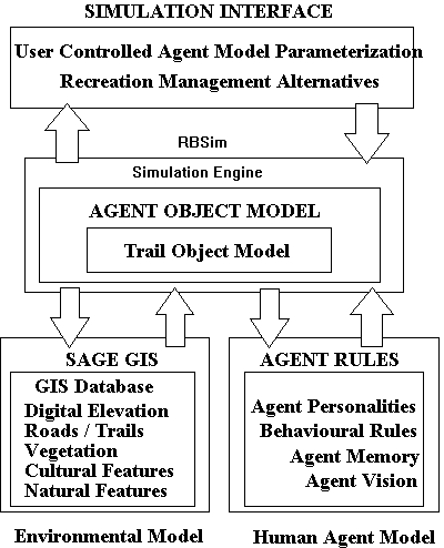
Figure 1 - Multi Agent Simulation System Design
H. Randy Gimblett
Associate Professor
School of Renewable Natural Resources
University of Arizona
Tucson, Arizona. USA
email:gimblett@nexus.srnr.arizona.edu
Robert M. Itami
Environmental Planner
Catchment Management and Sustainable Agriculture
Department of Natural Resources and Environment
P.O. Box 500
East Melbourne 3002
email: Robert.Itami@nre.vic.gov.au
There has been little research to understand the impacts of recreation use on public lands. Natural resource managers would benefit from simulation techniques to explore alternatives and test ideas or theories before expensive management plans are implemented. Recent research to model the dynamics of ecosystems have used object-oriented modelling and simulation languages, Geographic Information Systems (GIS), non-human agent design and simulations, yet no single system has been constructed to model the complex interactions of humans seeking recreational opportunities in wilderness settings. The purpose of this paper is to describe a decision support system for recreation management based on a simulation system using artificial intelligent agents integrated with GIS to allow natural resource managers to understand the complex spatial and temporal behaviour that arises from social interactions in wilderness settings. The simulation system called RBSim has been used to simulate the complex interactions between three classes of recreators in Sedona, Arizona. The utility of spatially explicit agent oriented simulations is demonstrated by simulating alternative trail configurations to compare differences in physical and visual contacts between recreation agents.
Due to pressures by an increasing diversity of recreators on wilderness land, conflicts are inevitable. Managing recreation in wilderness areas for optimal use while minimizing conflicts between recreators requires that the manager understand the needs, goals, and desires of recreators and the nature of conflicts within and between groups. This is by no means an easy task with an evolving wilderness clientele and a shrinking resource base. But in order to manage for multiple use, managers must first understand the nature of conflict (Richards and Gimblett, 1995).
There is still a gap between the needs of resource managers to achieve high level recreational experiences and/or beneficial outcomes, and the knowledge and tools available to examine the consequences of various alternative management strategies. On one hand information about wilderness recreationists’ attitudes and behaviour is increasingly viewed as important to the planning and management process. On the other, there is a need to acquire a better understanding and improve the theoretical foundation of recreation behaviour and conflict. While much of the theoretical exploration is left in the hands of the researcher, there is a continual need for theory building and testing of recreational use at multiple levels. These explorations are costly and often do not produce results that are useful to the resource manager. In addition, recent studies cast doubt on the traditionally held views of the influence of encounters, densities, and crowding on the expectations, experiences and satisfaction levels of recreators. There appears to be a need to develop new methods and tools for resolving some of these issues.
Due to the complexity of ecosystem dynamics, interest has increased in using GIS for simulation of spatial dynamic processes. Computer simulations have been utilized in variety of natural resource management applications from modelling animal populations (Stone, 1990 to hydrologic systems (Zhang et al. 1994). According to Itami (1994) "a great part of the challenge of modelling interactions between natural and social processes has to do with the fact that processes in these systems result in complex temporal-spatial behaviour. Vegetation dynamics, surface and subsurface hydrology, soil erosion processes, wild fire behaviour, population dynamics, disease epidemics, and urban growth are examples of processes that exhibit complex behaviour through time. It can be a daunting task to model each component of the system much less simulate the interactions between them. Yet with the rising awareness and concern for local effects on global climate and the need to understand how to maintain sustainable landscapes, it is more important than ever to develop theories and methodologies for understanding natural and human processes as complex dynamic systems."
The rapid development of accurate spatial databases using GIS has opened opportunities for resource scientists to extend the use of this data by integrating GIS with emerging technologies. Exploratory studies by (Gimblett et al. 1996a, 1996b; Saarenmaa et al. 1994) have incorporated artificial intelligence techniques with GIS. These studies show the potential benefits of integrating GIS with new technologies for improving resource management decision-making and point the way to the great potential for integrating emerging technologies such as robotics and artificial life with GIS.
The use of Individual-Based Models (IBM) is one of the popular approaches to modelling spatially-explicit ecological phenomena. IBMs according to Slothower et al. (1996) are "organism-based models capable of modelling variation among individual and interactions between individuals." Researchers such as Slothower et al. (1996) and Dibble, (1996) utilize IBM approaches in the study of a variety of ecological problems.
IBMs offer potential for studying complex behaviour and human/landscape interactions within a spatial framework. Since spatial information about a phenomena is stored on a georeferenced coordinate system, space within a grid is implicit and relative to the origin of the grid (Slothower et al. 1996). IBMs offer some basic advantages over current cellular automata and other dynamic spatial modelling approaches for examining spatially explicit phenomena. Since space is continuous and location is explicit in IBMs, individuals can be simulated, independent of the environment. This provides the modeler with the ability to define an individual’s behaviour, personality traits and interaction rules when encountering other individuals. Computer modelling of most ecological phenomena evolves in simulated time. Since space is continuous and individuals are represented independently, temporal and spatial variability in IBMs can be handled asynchronously (individually updated) versus synchronously (global update) common to most raster-based GIS systems.
One form of individual-based modelling approaches that has recently gained popularity is artificial intelligent agents. Intelligent agents or what is referred to as ‘agent-oriented programming’ is being used to capture behavioural conditions and sets of intercommunication among and within agents that coexist in an environment. These agents interact and react with their environments - hence they are active objects with some partially determined set of goals. This school of thought professes that agent behaviour is an intensive interaction and emergent property. The environment is taken into account dynamically. Its characteristics are exploited to serve the functioning of the agent. A complex agent has complex goals, but behaviour to meet the goals develops or emerges as the agent learns more about its surroundings. While these simulations have been successfully implemented in contrived environments, real biophysical environments have not yet been explored.
The few studies to date that have explored emergent behaviour in individuals or societies have not used GIS for representing the spatial worlds behavioural interactions within those worlds. Since human behaviour is inherently spatial, GIS can provide the worlds that individuals could respond to and function within. Currently, there is no GIS system with IBM capabilities. Dibble (1996) states that "individual-based models do currently exist (Langton et al. 1995) and in many ways these systems may offer far deeper insights into human geographic phenomena than any current GIS."
In summary, despite the development of object-oriented modelling and simulation languages, GIS, non-human agent design and simulations, no single system has been constructed to handle the complexity of goal-oriented autonomous human-like agents seeking recreational opportunities while minimizing conflicts in natural environments. While GIS alone cannot solve this problem, it can provide two and three dimensional data of the real world, location and positional information on the earth's surface, and the capability to store semantic knowledge about qualities of landscape, crucial for human behavioural modelling. Artificial Intelligence (AI) on the other hand can provide the added benefit of capturing and storing knowledge about sociological functioning of humans such as interaction traits, preferred movement patterns and rates etc, and biological requirements such as rest, sleep, nourishment etc. as decision rules. If these are incorporated into an integrated modelling and simulation system, they can provide a tool to aid the manager in making more informed decisions about forest recreation environments.
The desire to develop a practical tool for use by resource managers for simulating recreation behaviour in wilderness settings, has led to the development of RBSim. RBSim was developed as a specific application using features and concepts from the other agent modelling systems (Langton et al. 1995) with the addition of direct object links to GIS operators. RBSim is a computer program that simulates the behavior of human recreators in high use natural environments. Specifically RBSim uses concepts from recreation research and artificial life and combines them with GIS to produce an integrated system for exploring the interactions between different recreation user groups within real geographic space. RBSim joins two computer technologies: GIS to represent the environment; and Autonomous Human Agents to simulate human behaviour within geographic space.
RBSim demonstrates the potential of combining the two technologies to explore the complex interactions between humans and the environment. To demonstrate the utility of the simulation tool, data was collected using social survey techniques on three recreation groups in Broken Arrow Canyon near Sedona, Arizona, over a nine month period. The canyon is popular for hikers, mountain bikers and people on commercial jeep tours because of the unique spectacular desert scenery of eroded red sandstone. Sedona is well known by New Age enthusiasts for its "Spiritual Vortex". This, combined with the close proximity to the Grand Canyon, Monument Valley and the Navaho and Hopi Indian Reservations, make it an important tourist destination by visitors around the world. The upshot of this popularity is a problem common to many popular wildland recreation destinations. People are "loving the place to death" by overuse. This overuse not only has negative impacts on the landscape but also on the quality of the experience people have when they visit. Crowding, conflicts between hikers, mountain bike enthusiasts and jeep tours can create negative experiences in what should be a spectacular and memorable landscape setting.
The U.S. Forest Service is responsible for managing the resource. They must have guidance on what actions to take to protect the environment and provide the best possible recreation experience for visitors. Options include building new trails, limiting the number of visitors, or relocating existing trails. Any of these strategies or combinations of these strategies has complex consequences on the net experience of visitors. There have been no tools available to natural resource managers to study these complex interactions. RBSim has been developed to address these complex issues by using computer simulation technology. By simulating human behavior in the context of geographic space, it is possible to study the number and type of interactions visitors will have within each group and between groups.
RBSim is programmed using Microsoft Visual Basic 4.0 with object-oriented classes, properties and object structure. It is designed using a logical structure of agents, interacting through discrete events. In RBSim, agents (hikers, mountain bikers and jeeps) are instances of a recreator object class. Each class contains the behavioural rules and state variables necessary for defining various types of agents. A simulation proceeds in discrete time steps. Individual actions of a recreator agent are triggered either by environmental context (stop to look at a view, slow down to climb a steep slope) the result of social interactions (a crowded site may result in an agent moving on, rather than stopping at a view), or by "internal" events (reduced energy levels may trigger the need to rest).
Figure 1 below illustrates the components of the modelling framework. The simulation interface provides a mechanism for the user to control input variables, while the simulation engine keeps track of timing and all global parameters. The agent object model is the heart of the simulator which serves to characterize agents and define subclasses for each agent. The trail object model is also a member of the agent object class and communicates directly with recreator objects developed specifically for this application. In a typical run agents, created from input parameters randomly, respond to a specific set of rules. Depending on the agent they vary in speed, energy levels and objectives or goals.
The software was designed around three types of agents; hiker, mountain bikers and jeep tours. To test the prototype, recreator profiles for each of the recreator types were derived from analyzing the survey data collected in Broken Arrow Canyon. Two unique personality types dominated the characteristics of recreators that visited the canyon. They are defined as landscape and social recreators. A landscape type can be defined as solitude seeking. They traverse the canyon minimizing encounters with other agents. These agents will pass other agents along the way, stop at scenic lookouts only when there are less that four other recreators present. These behaviours coincide with the desired benefits extracted earlier in the survey. Seeking physical exercise, avoiding crowds and enjoying nature are strongly correlated benefits of this group of recreators.
Figure 1 - Multi Agent Simulation System Design
Social recreators on the other hand move slower along the trails, will stay close to other recreators they encounter and will stop at all scenic lookouts, regardless of the number of other recreators present. These agents are characterized as seeking some minimal level of physical exercise, have no need to avoid crowds and are out there to take their time and enjoy nature. These are strongly correlated benefits of this group.
Landscape and Social agents were designed to simulate the behaviours of both recreator types. All agents keep track of the number of visual and physical encounters they have as they move along the trail. A hiker’s visual encounter for example is the sight of other visitors from along the hiking trail (For detailed discussion on the agent visibility model see Gimblett, 1997). For the RBSim agents, memory is important to their understanding of the location of other agents are the simulated world. All agents evaluate and keep track of other agents that fall into their visual field and are summarized for each cell they are currently in. Each agent knows at all times: where it is (cellular location), where it has been, how long it has been there in real and simulated time, how far it has traveled, current energy levels, energy loss and how many and which types of agents fall within a specified distance and can be seen. Each agent has a record of where and how many visual encounters it has with other agents as it is moving through the landscape over time. While each agent keeps track of other agents it sees, the trail object model keeps track of the number of agents that are physically encountered in each cell throughout the simulation. This information is subsequently used to determine spatially represented physical and visual encounters and movement patterns along the trails. This information is used to graph the number of encounters overtime for each of the agents being studied.
Before the simulation can be executed, a number of parameters must be set up. First, a trail file must be selected for each type of agent included in the simulation. For evaluation of recreational use in Broken Arrow Canyon, all agents are programmed to follow trails. This was done for several reasons. First, all trails lead to specific geologic features of interest to the recreators which are among the important reasons visitors come to the canyon. Second, Pink Jeep Outfitters are required to follow specific trails in the Canyon and in order to evaluate visual and physical encounters between jeeps and other recreational use, it is imperative that they follow trails. Third, this simulation tool will be used to examine new trails and the development of management plans for trail use in the canyon. The trail files are preconstructed in the GIS and the user can easily incorporate other desired trails into the simulation environment.
In order to test some of the ideas and concepts presented in this research and to determine the efficiency of the simulation system in identifying conflicting recreation behaviour, a set of experiments have been constructed. In order to make these experiments as realistic as possible, data from the Broken Arrow user survey was used to derive agent personalities. During the interview and survey phase of this research, visitors to Broken Arrow Canyon were asked to record the month, day and time that they entered the canyon. In order to demonstrate the utility of the software for assessing recreation conflicts in Broken Arrow Canyon, six experiments were established that reflected the distribution of peak and off times of recreation visits to the canyon. This paper will present two, one under the normal use conditions and the other modifying the bike trail to demonstrate the reduction in the number of conflicts.
Figure 2 illustrates the number of visual encounters that occur along the hiking trail. As the simulation reveals, hiker’s encounters with other hikers is relatively low until the turnaround point in the trail, where there is a significant increase. The congestion created at the lookout points is a result of these behaviours and can explain why numbers of encounters generally increase throughout the simulation. The number of visual encounters that hikers have with bikers is high at the beginning and tends to vary through the simulation run. Figure 2 clearly identifies areas where the encounters occur. These areas correspond to the last two stops or lookouts and to the last half mile of the journey. With six jeeps in the simulation there appears to be only minimal conflicts that occur. In fact, the conflicts from hiker agents is almost nonexistent.
In summary it is clear that with thirty recreator agents in the canyon there are considerable visual encounters within and among hikers and bikers, but a relatively low amount of encounters with jeeps. Even among jeeps there is a minimal number of encounters. It is clear that there are explicit spatial locations during specific time periods where conflicts do occur.
Selecting alternative bike trails can have a major impact on the number of encounters that occur along the trails. It can be seen in Figure 3 that when alternative bike route 2 is used in the simulations, the number of biker encounters that the hikers will have decrease significantly to the point that they are again negligible after trail section 360. When compared to Figure 2, by altering the trail layout the mean number of encounters has dropped by two thirds and the maximum number of encounters by more than half.
Figure 3 illustrates that while hiker encounters with other hikers and jeep encounters are not significantly effected by the alternative bike trail, encounters with bikers are severely reduced. Reducing biker encounters would, from a hikers perspective reduce thirty percent of the conflict.
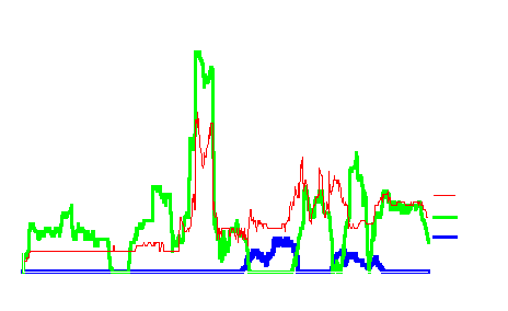
Figure 2 - Results of Hiker Encounters with Other Agents from along Hiking Trail

Figure 3 - Results of Hiker versus Other Agent Visual Encounters using Biking Alternative Trail
What is of interest however is when comparing Figure 2 using the original bike route with Figure 3 encounters are extremely low and there are places in the landscape where there are no encounters at all. Between trail sections 401 and 801 there are no other encounters. Encounters with other biker agents tend to steadily increase over the remainder of the trail. It is only near the end, where encounters with other agent types occur again. Since biker encounters with other bikers has no significant negative impact on each other, this solution offers distinct advantages.
The agent simulations seem to be an excellent method for modelling recreator encounters and ultimately conflicts. While statistical results of the survey used in this study provide an indication of the average number of encounters (viewed as negative detractors), the agent simulations provide a dynamic view of these encounters and identify the locations where they occur. The effect of these encounters on the overall recreational experience is still unknown. However, this simulation environment provides a way to test and evaluate many scenarios of recreational use. While the survey provided a quantitative measure of the recreational experience, the simulation environment provides a dynamic, spatial representation of use and provides the added benefit of collecting and storing data on encounters over time. Both these data can be evaluated using conventional statistical techniques and compared to explain commonalties and differences.
Of interest in this research, and showing the power of using simulation, is the impact of alternative routes on recreator encounters. An examination of the biker trail alternatives as suggested by the respondents to the survey, illustrate the importance of a well thought out trail design on recreational encounters. As can be seen in this research both alternative trail designs significantly reduce the number of encounters with other recreators. It is clear that the simulation environment can assist in evaluating existing and proposed trails in an attempt to minimize encounters and conflicts which ultimately lead to a decline in recreational experience.
What is imperative to emphasize in this work is that simulation of any dynamic behaviour cannot be accomplished without techniques like RBSim. Simulation using personality traits and behavioural rules synthesized from human recreators provide a forum to evaluate and test a diversity of recreator use densities over time. These alternatives can be used to develop new facilities along the trails, and to redirect trail use to maximize user satisfaction while minimizing impact. Being capable of seeing the agents interacting under a variety of constraints can assist the manager in acquiring a better understanding of the recreators using public lands.
Dibble, C. Representing Individuals and Societies in GIS. NCGIA Santa Barbara. http://www.geo.wvu.edu/www/i19/ dibble.
Gimblett, H. R., B. Durnota & R. M. Itami. Conflicts in Recreation Use in Natural Areas: A Complex Adaptive Systems Approach. Third Australian Complex Systems Conference. Charles Sturt University. Albury, Australia. July 14-18, 1996a.
Gimblett, H. R., R. M. Itami & D. Durnota. Issues in Designing and Calibrating Artificial Human Agents.Workshop Comparing Reactive (ALife-ish) and Intentional Agents. Charles Stuart University. Albury, Australia. July 19, 1996b.
Gimblett, H.R. 1997. Simulating Recreation Behaviour in Complex Wilderness Landscapes Using Spatially-Explicit Autonomous Agents. Unpublished Ph.D.dissertation. University of Melbourne. Parkville, Victoria, 3052 Australia.
Itami, R. M. Simulating Spatial Dynamics: Cellular Automata Theory. Landscape and Urban Planning 30 (1994) pps. 27-47.
Langton, C., N. Minar & R. Burkhart. The Swarm Simulation System: A tool for studying complex systems. Santa Fe Institute, Santa Fe, New Mexico, USA, http:// www.santafe.edu/ projects/swarm/ swarmdoc/swarmdoc.html, 1995.
Richards, M. T. & H. R. Gimblett. Recreation Assessment of Forestlands in Ecosystem Management: A Conceptual Model. U.S. Rocky Mountain Research Station Research Report. July, 1995.
Saarenmaa, H., J. Perttunen, J. Vakeva & A. Nikula. Object-oriented modeling of the tasks and agent in integrated forest health management. AI Applications in Natural Resource Management. 8 (1), pps. 43-59. 1994.
Slothower, R. L., P.A. Schwarz & K.M Johnson. Some Guidelines for Implementing Spatially Explicit, Individual-Based Ecological Models within Location-Based Raster GIS. Third International Conference Integrating GIS and Environmental Modeling. January 21-25, 1996. Santa Fe, NM.
Stone, N. D. 1990. An Object-Oriented Approach to Modeling Arthropod Predator Prey Interactions. In: Proceedings of Resource Technology '90. Washington, D. C. November, 1990.
Zhang, X., V. Lopes & G. Ball. 1994. Integrating Hydrology Models and GIS: A Preliminary System Design. SRNR Report #94-1. School Renewable Natural Resources. University of Arizona.