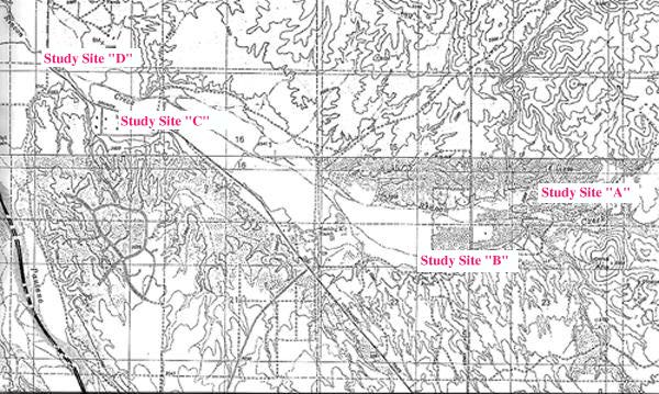
Rincon Creek Riparian Study Context Map
(For summary data and maps of each study sites, select one of the above)
The location and length of study sites for this inventory were determined primarily by two factors. First, the realities of land ownership limited access to only certain reaches of Rincon Creek. The Rincon Institute gained permission to perform the work associated with the inventory on land within Rocking K Ranch and on several private properties up- and down-stream from the Rocking K; at these locations, sites were chosen that were long enough to encompass three transect lines placed across the channel at random intervals of at least 40 m (see Measuring Channel Cross Sections below). Second, study sites had to be selected so that data collected were representative of the selected reach. This required each site to be positioned in an area uninfluenced by unique geologic features, tributaries, or human structures (e.g., bridges or roads) that affect streamflow and vegetation.
Four study sites were identified along a 12-km reach of Rincon Creek (see Fig. 2 - pocket). Study sites A and B are located upstream from the Rocking K Ranch; Study Site A is 3 km (1.85 miles) upstream from Camino Loma Alta, and Study Site B is .3 km (.2 m) upstream from Camino Loma Alta. Study Site C is located on the Rocking K Ranch, 3.9 km (2.4 m) downstream from Camino Loma Alta, and .8 km (.5 m) upstream from Old Spanish Trail. Study Site D is located downstream from the Rocking K Ranch, 4.7 km (2.9 m) downstream from Camino Loma Alta, and .2 km (.1 m) upstream from Old Spanish Trail.