
Presented at AURISA 99 - The 27th Annual Conference of AURISA
Blue Mountains, New South Wales, 22-26 November 1999
Presented at AURISA 99 - The 27th Annual Conference of AURISA
Blue Mountains, New South Wales, 22-26 November 1999
RBSim: Using GIS-Agent simulations of recreation behavior to evaluate management scenarios
Bob Itami1, Randy Gimblett 2, Rob Raulings3, Dino Zanon4, Glen MacLaren5, Kathleen Hirst6, Bohdan Durnota7
2School of Renewable Natural Resources
Biological Sciences East 325
University of Arizona
Tucson, Arizona USA 85721
Phone: (520) 621 6360
Email: Gimblett@Ag.Arizona.Edu
3Reality Mechanics
Level 1, Century House
132 Gwynne St
Richmond, Victoria Australia 3121
Phone (03) 9427 9233 Fax: 03 9427 9808
Email: rob@realmech.com.au
4Parks Victoria
378 Cotham Rd.
Kew, Victoria Australia 3101
Phone: 03 9816 6808 Fax: 03 9816 7098
E-mail: dzanon@parks.vic.gov.au
5Environmental Systems Solutions
9 Pearl Street
West Essendon, Victoria Australia 3040
Phone: 03 9337 9022
Email: g.maclaren@eng.unimelb.edu.au
6GIS Applications Pty Ltd.
P.O. Box 113
South Caulfield, Victoria Australia 3162
Phone/Fax: 03 9523 5323
E-mail: khirst@netspace.net.au
7Decisioneering Pty Ltd.
P.O. Box 23
Doncaster, Victoria Australia 3108
Phone: 03 9928 4200 Fax: 03 9816 7098
E-mail: complexibotics@complexibotics.com
This paper describes advancements in recreation management using new technology that couples Geographic Information Systems (GIS) with Intelligent Autonomous Agents to simulate recreation behaviour in real world settings. RBSim is a computer program that allows park management to explore the consequences of change to any one or more variables so that the goal of accommodating increasing visitor use is achieved while maintaining the quality of visitor experience. RBSim provides both a qualitative understanding of management scenarios by the use of map graphics from a GIS as well as a quantitative understanding of management consequences by generating user statistics during the simulation. Managers are able to identify points of over crowding, bottle necks in circulation systems, and conflicts between different user groups
RBSim is designed to be easy to use by Parks Victoria staff. This is facilitated through a tight integration with MapInfo GIS which allows a practical solution for quickly building complex simulation models. Simulation techniques provide methods for evaluating details of management decisions as they impact visitors and the environment. No other analysis tool which achieves this level of understanding is currently available.
The paper describes RBSim and its application to simulating and evaluating alternative park management scenarios.
KEYWORDS:
Geographic information systems, Artificial Intelligence, Intelligent Agents, Recreation Management, Simulation Modelling
Simulating Visitor Use with RBSim
RBSim is a computer simulation tool, integrated with a Geographic Information System (GIS) that is designed to be used as a general management evaluation tool in any park in Australia. This capability is achieved by providing a simple user interface that will import park information required for the simulation from the MapInfo geographic information system. Once the geographic data is imported into RBSim, the park manager will then be able to easily set other variables in the management model. Some of the factors the manager can change include the number and kind of vehicles, the number of visitors, and facilities such as the number of parking spaces, road and trail widths and the total capacity of facilities
RBSim allows park management to explore the consequences of change to any one or more variables so that the quality of visitor experience is maintained or improved. Statistical measures of visitor experience are generated by the simulation model to document the performance of any given management scenario. Management scenarios are saved in a database so they can be reviewed and revised. In addition, the results of a simulation are stored in a database for further statistical analysis. The software provides tables and graphs from the simulation data so park managers can identify points of over crowding, bottle necks in circulation systems, and conflicts between different user groups.
RBSim will also allow park managers to compare alternatives by experimenting with different policy levers that can operate within the software. Such levers may activate or deactivate rules which agents in the RBSim environment will follow as they move through the environment of the Park.
RBSim - Recreation Behavior Simulator
RBSim is a computer program that simulates the behavior of human recreators in high use natural environments. Digital Land Research in Melbourne, Victoria Australia, first developed RBSim in 1997. Specifically RBSim uses concepts from recreation research and artificial intelligence (AI) and combines them in a GIS to produce an integrated system for exploring the complex interactions between humans (recreation groups) and the environment (geographic space) (Gimblett et al. 1996a; Gimblett et al. 1996b, Gimblett 1997a, Gimblett et al. 1997b). RBSim joins two computer technologies:
What is an autonomous agent?
RBSim uses autonomous agents to simulate recreator behavior. An autonomous agent is a computer simulation that is based on concepts from Artificial Life research. Agent simulations are built using object oriented programming technology. The agents are autonomous because once they are programmed they can move about their environment, gathering information and using it to make decisions and alter their behavior according to specific environmental circumstances generated by the simulation. Each individual agent has it's own physical mobility, sensory, and cognitive capabilities. This results in actions that echo the behavior of real animals (in this case, human) in the environment.
The process of building an agent is iterative and combines knowledge derived from empirical data with the intuition of the programmer. By continuing to program knowledge and rules into the agent, watching the behavior resulting from these rules and comparing it to what is known about actual behavior, a rich and complex set of behaviors emerge. What is compelling about this type of simulation is that it is impossible to predict the behavior of any single agent in the simulation and by observing the interactions between agents it is possible to draw conclusions that are impossible using any other analytical process.
Why RBSim is important to recreation managers
RBSim is important because until now, there have been no tools for recreation managers and researchers to systematically investigate different recreation management options. Much of the recreation research is based on interviews or surveys, but this information fails to inform the manager/researcher how different management options might affect the overall experience of the user. For example if a new trail is introduced, there will ultimately be conflicting recreation uses. How do different management options increase or decrease the potential conflicts? Questions like these can not be answered using conventional tools. These questions all pivot around issues such as time and space as well as more complex issues such as inter-visibility between two locations. By combining human agent simulations with geographic information systems it is possible to study all these issues simultaneously and with relative simplicity.
Application of RBSim in Wildland Recreation Settings
RBSim was programmed by Digital Land Systems Research in Melbourne, Australia in 1997 in collaboration with Randy Gimblett who was developing a Ph.D. dissertation on the use of simulation models in recreation management at the University of Melbourne. Since that time RBSim has become recognized as an innovative, practical and cutting edge approach to simulating the complex consequences of alternative management plans in the United States. These studies are briefly described below.
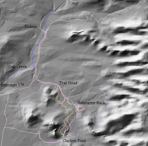
Broken Arrow Canyon, Sedona Arizona
RBSim was originally developed to simulate recreation conflicts in Broken Arrow Canyon near Sedona, Arizona. The U.S. Forest Service is responsible for the recreation management of the Canyon. Sedona is popular for hikers, mountain bikers and people on commercial jeep tours because of the spectacular desert scenery of eroded red sandstone. Sedona is well known by New Age enthusiasts for its "Spiritual Vortexes". These attractions, combined with the close proximity to the Grand Canyon, Monument Valley and the Navaho and Hopi Indian Reservations, make it an important tourist destination by visitors from around the world.
The resource managers for this area seek guidance on what actions to take to protect the environment and provide the best possible recreation experience for visitors. Options include building new trails, limiting the number of visitors, or relocating existing trails. Any of these strategies, or combinations of these strategies, have complex consequences on the net experience of visitors. By simulating human behavior in the context of geographic space, RBSim makes it possible to study the number and type of interactions visitors will have within and between groups.
Colorado River, Grand Canyon National Park, Arizona
River recreation along the Colorado River through the Grand Canyon National Park is a perfect example of increasing pressures and severe impacts from visitors on a sensitive, dynamic ecosystem. Each year, over 23,000 individuals and another 3,700 guides, researchers, and park staff travel through the Grand Canyon on the Colorado River on commercial or noncommercial river trips which are offered on a variety of watercraft powered by oars, paddles or motors, and vary in length and duration.
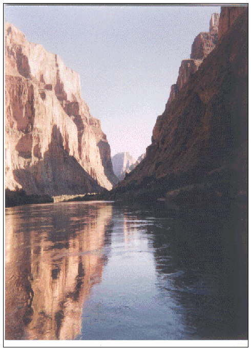
Major impacts of repeated recreational use are evident at the major rapids and attraction sites including multiple trailing, proliferation of campsites, disturbances of cultural features, destruction of sensitive vegetation etc. Extensive crowding and congestion have resulted at many of the attraction sites from both on and off river use.
The Colorado River Management Plan (CRMP) has been established to protect the natural resource and includes management objectives that address the quality of the visitor experience. The plan establishes long-term integrated monitoring programs to assess the experiential environment as well as changes in the natural and cultural resources. These programs were implemented in 1989 to monitor visitor experience using crowding and contacts as indicators
Previous research studies have attempted to monitor river recreation use and impacts along the Colorado River. There is still a significant gap between the needs of natural resource managers to provide high level recreational experiences and the knowledge and tools available to explore the spatial and temporal consequences of various alternative site management and river trip scheduling strategies.
RBSim is currently being modified to simulate the current river use patterns of commercial tour operators in the Grand Canyon. In addition, managers wish to test alternative management strategies including alternative timetables for starting trips, booking specific riverside campsites for different sized boating parties. These strategies are aimed at reducing conflicts between different boating parties, reducing environmental impact on river beaches, and increasing the number of river users.
RBSim will be used to integrate knowledge about river flows, environmentally sensitive areas, and river use patterns. Existing GIS maps of the Grand Canyon will be used to set up the simulation model and alternative management scenarios will be tested to determine the outcomes in terms of crowding, environmental impacts and total number of users through the river system.
Port Campbell National Park and Bay of Islands Coastal Park
Parks Victoria has the responsibility for management of over 3.8 million hectares of parks and reserves in Victoria, or 16% of the total area of Victoria. One of the major natural resource initiatives in Parks Victoria's 1997-8 corporate plan is to gain a clear understanding of the natural resources under Parks Victoria management and in the development of systems to guide future resource allocation, including the abilities to support management decision making and reporting.
Underlying the use of Victoria's parks are two key assumptions: firstly that the visitor use and tourism in parks contributes to individual and collective well being, inspiration, education and economic prosperity, and secondly that visitor use and tourism must be environmentally sustainable in order to maintain or improve the first assumption.
Because the management of visitor services requires a significant proportion of available resources, there is a real need for improvements in understanding relationships between visitor use, customer satisfaction and the condition of the natural environment. These better understandings will allow the improvement in management of resources and in making effective use of limited financial resources, whilst maintaining or improving the condition of the environment.
Port Campbell National Park and the Bay of Islands Coastal Park are located on the Great Ocean Road, approximately 250 Km west of Melbourne. Comprising 65 Km of rugged and spectacular coastal scenery, the two parks are protected in a strip ranging in width from a few metres in the Bay of Islands park to 2 km within the Port Campbell National Park.
The parks have World Conservation Union (IUCN) ratings of Category II (National Parks) and Category III (National Monuments) and are designated for ecosystem conservation and appropriate recreation and protection of outstanding natural features, education, research and recreation respectively.
In addition to the main park attractions of coastal views, walks and water-based recreation, there are a range of other significant regional attractions from the Otways National Park to State Parks and the historic towns of Warrnambool and Port Fairy.
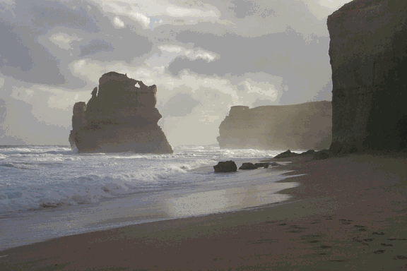
Figure 3. Beach at Gibson's Steps, Port Campbell National Park, Victoria, Australia (photo by Itami)
The Port Campbell National Park and the Bay of Islands Coastal Park attract large and steadily increasing numbers of visitors (2.1 million visits per year in 1996/97 combined between both parks). Annual growth rate of the visitors is estimated at 5.7%, although it may be higher at some key sites.
This increase in visitation suggests that by 2001/2 there will be approximately 2.75 million visits per year to Port Campbell and Bay of Islands combined, causing considerable load on facilities and pressure on the coastal ecosystem. By 2006/7 this is expected to rise to 3.7 million combined visits per year for the parks.
The Visitor Management Project for Port Campbell National Park and Bay of Islands Coastal Park is a unique opportunity in Australia to demonstrate the use of GIS based recreation simulation as a cutting edge tool for evaluating alternative management scenarios. Like the U.S. examples, the Victorian study is typified by the high value the public places on the landscape which leads to the consequential heavy visitor use, and the inevitable crowding and decline of visitor satisfaction and environmental quality. RBSim can be used as a generic management tool for any park in Victoria, Australia or the rest of the world. The reason why this is possible is because of the links between GIS datasets and the simulation model. This facility immediately "localizes" the software to the specific conditions of each park and allows park planners and managers to quickly and easily build complex management scenarios to be simulated. The GIS approach makes the simulation model easy for policy makers, planners, managers and the public to understand.
RBSim Components
GIS Interface for RBSim
Parks Victoria uses MapInfo as its corporate GIS. RBSim has a custom user interface to import park features such roads, trails, parking lots, view points, and picnic facilities from MapInfo GIS. A Visual Basic program is used in conjunction with MapInfo's MapX ActiveX control to build the custom interface. Park features are classified and attributed using the interface to meet the specialized requirements of the RBSim simulation model. All features are treated as objects as described in the following section.
RBSim object models
Network data structure for trails, roads, rivers and other linear features
This object module will support one way and two way direction flows, single or multiple lanes of traffic, road speed and capacity information, surface characteristics and other pertinent attributes that affect visitor movement through the park either on foot or in a vehicle. The MapInfo interface described above reads in the unstructured "spaghetti" vectors in MapInfo and generates a topologically structured network database. The network is attributed for surface condition, design speeds, width, and other factors relevant to the simulation. Turning impedences at intersections are applied using a classification table that allows the user to assign impedances to all intersections with similar attributes simultaneously.
Site Objects
Sites such as picnic sites, overlooks, parking lots are programmable objects. They have property screens so the user can easily change the configuration of the object by double clicking on the object as it appears on the screen. As with the recreation agents, site objects are saved in the project database. Objects such as parking lots need to track the entrance and exit of agents such as cars, buses, and pedestrians.
Agent object model
Classes of agents such as cars, buses and helicopters are agents in themselves but also can transport other agents. All agents will be stored in the project database and can be customized by a user-friendly graphical interface. All agents have properties and methods that will determine mode and speed of travel. In addition, each agent has a "trip plan". The trip plan is a sequenced list of destinations which, for vehicles are derived from trip matrices for the park. Trip matrices are generated from vehicle count information and license plate surveys in the park. For pedestrians, trip plans are determined either from observations of typical user behavior on site, or by park managers or planners familiar with user patterns on site. The agent may need to alter the trip plan during the simulation due to crowding or shortage of time to execute the plan due to day length or other circumstances. When a trip plan must be altered, the agent uses a set of internal "personality" characteristics and estimated times to visit alternative destinations to "prune" the trip plan to meet the constraints of the new circumstances. These decisions are programmed using the Analytical Hierarchy Process (AHP) developed by Saaty (1995) to weight various trip options.
Simulation Engine
The simulation engine can execute scheduled runs where agents are parameterized and entered into the simulation from an external file. Alternatively the user can generate a simulation schedule by providing a trip matrix and a distribution of user numbers over the time period of the simulation (hourly or daily) The simulation engine generates agents during the simulation according to the distribution of users. Agents are then initialized with a trip plan as determined from the trip matrix. In addition mode of travel (bus, car, helicopter, bicycle, or on foot) is assigned to the agent as well as expected trip duration. Once the agent is initialized and entered into the simulation, the agent uses it's own reasoning system to navigate and make decisions based on the environmental characteristics or number and type of other agents it encounters during the simulation.
Management Scenario designer
The Management Scenario Designer allows the user to edit an abstract diagrammatic representation of the simulation. Site objects such as parking lots will be able to be added or deleted, roads and trails will be able to be added, deleted or modified to increase the width, increase or decrease the road speed, etc. The user then parameterizes the object by double clicking on its instance to reveal a form that the user fills out to parameterize the object. This will allow the user to quickly "edit" a management scenario, save it in a new simulation file and then re-run the scenario to see if there are improvements or problems identified in the simulation.
Simulation Statistics Module
Standard tools for statistical analysis of simulation outputs identify points of conflict or overcrowding, bottle necks in the system and other problems with the management scenario. Comparisons between scenarios allow the manager to determine if a management strategy improves or degrades the capacity of the system to handle different user loads.
Simulation Outputs
RBSim provides a standard set of tools for generating graphs, tables, maps and reports from the results of the simulation and statistical analysis.
Intelligent agents in geographic space
A fundamental innovation in RBSim is the integration of Geographic Information Systems (GIS) data into an agent-based simulation. The map data from the GIS provides an accurate representation of real world landscape features. GIS systems are complex systems, with their own command language, graphic display systems, user interfaces, analytical capabilities, and data formats. This complexity makes it difficult to integrate with other systems. There are essentially two ways of integrating GIS with agent simulation models:
The first option has the advantage of requiring little additional programming to gain the full functionality of the GIS. The disadvantages revolve around the appropriateness of standard functions in the GIS to the agent simulation model and the slow speed at which some of these functions operate. If a GIS function takes more than a few seconds to run (which is common), this makes the simulation run unacceptably slow. If the GIS will not perform a function that is needed in the simulation model, then one must build a custom program to produce the desired result anyway.
The second option has the disadvantage of increasing the size and complexity of the simulation program by requiring the need to support input/output functions to read and write to GIS map databases as well as the need to write the analytical routines to process the geographic data sets. The advantages are that custom functions can be written and the code can be optimized for speed to ensure better performance from the simulation run. RBSim takes this approach.
GIS map layers
RBSim uses a raster or grid cell GIS database for representing environments. A grid cell GIS represents a map as an evenly spaced set of grid cells. A grid cell GIS has many advantages for agent simulations. First, grid cells simplify the problem of representing continuous data such as elevation; second the need for performance in simulation models is facilitated by grid cell representation since it is easy to subset spatial data for local processing.
The detail or resolution of the map is determined by cell size. A 10-metre cell represents an area 10 metres by 10 metres (100 square metres). A 20-metre cell represents and area 400 square metres but stores only a quarter of the detail of a 10-metre cell. Features are represented by numeric values assigned to each corresponding cell in the map. For instance, in a map of trails, a value of 1 might be assigned to walking trails a value of 2 to biking trails and a value of 3 to jeep trials.
In the case of simulating recreation behavior, it is necessary to have a fine scale database to adequately capture the characteristics of the landscape that are important to the recreation experience. Factors impacting the selection of cell size relate to the scale of the original map data, the complexity and density of site features captured in the map data, and at what level of accuracy movement of agents through the database are to be tracked. The first environment simulated in RBSim was a forest recreation area called Broken Arrow Canyon near Sedona, Arizona. The cell size selected for this simulation model was 10 metres. This captured the complexity of the trail layout and the major site features along the trails. In a simulation for the Grand Canyon a cell size of 90 metres has been selected because of the length of the canyon, and the relatively coarse level of information along the course of the river.
Once the logistics of reading raster GIS datasets is worked out, any number of specialized analysis techniques can be employed to provide the agents with spatial analytic capabilities that can be used as inputs into the agent's reasoning system.
Conclusions
The agent simulations are an excellent method for modeling recreator encounters and ultimately conflicts. The agent simulations provide a dynamic view of encounters between agents and identify the spatially explicit locations where they occur. The effect of these encounters on the overall recreational experience is still unknown. However, this simulation environment provides a way to test and evaluate many scenarios of recreational use.
RBSim is a significant step forward to make linkages between GIS, multiagent systems and recreation behavior modeling. By generalizing the software to parameterize a simulation from existing GIS datasets (in this case MapInfo), the RBSim simulation platform can be used to study management alternatives in any park in Australia. The tight integration with GIS also allows ancillary models such as environmental impact models and economic models to be integrated into the simulation. Park managers can then test many different management assumptions in both qualitative and quantitative terms before committing resources to expensive construction projects.
References
Gimblett, H.R., B. Durnota & R.M. Itami (1996a). Spatially-Explicit Autonomous Agents for Modeling Recreation Use in Complex Wilderness Landscapes. Complexity International Journal. Volume 3, July.1996.
Gimblett, H.R., R. M. Itami & D. Durnota.( 1996b) Some Practical Issues in Designing and Calibrating Artificial Human Agents in GIS-Based Simulated Worlds. Complexity International Journal. Volume 3, July, 1996.
Gimblett, H.R. (1997a). Simulating Recreation Behavior in Complex Wilderness Landscapes Using Spatially-Explicit Autonomous Agents. Unpublished Ph.D. dissertation. University of Melbourne. Parkville, Victoria, 3052 Australia.
Gimblett, H.R. & R. M. Itami(1997). Modeling the Spatial Dynamics and Social Interaction of Human Recreators Using GIS and Intelligent Agents. MODSIM 97 - International Congress on Modeling and Simulation. December 8-11, 1997. Hobart, Tasmania.
Integrated Management Systems (1998). Port Campbell-Bay of Islands Visitor Survey, Final Report., Melbourne, Victoria, Australia.
Saaty, Thomas L. (1995) Decision making for leaders: the analytical hierarchy process for decisions in a complex world. Published Pittsburgh, Pa. RWS Publications.