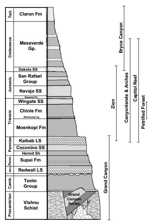
 Geology of the Verde Valley - February 26, 2014 Jeff Schalau, Agent, Agriculture & Natural Resources University of Arizona Cooperative Extension, Yavapai County The February meeting of the Yavapai County Master Gardener Association hosted renowned author, adventurer, geologist, and interpreter, Wayne Ranney. Here, Wayne presented complicated geologic processes using pictures and maps that followed the Verde Valley’s geologic history starting 1,750 million years ago (Ma). You might wonder “what relevance does this have to gardening?” It is very relevant when you consider the minerals and parent rocks that have weathered into our local soils and the hydrology that feeds the Verde River, its tributaries and our many springs. Wayne discussed how some layers of sedimentary rocks visible in the Verde Valley are also visible in the Grand Canyon. The sedimentary rock deposits that developed during the Triassic and afterwards (240 Ma) are visible to the north in Arizona (Petrified Forest) and Utah (Canyonlands, Arches, Zion, Capital Reef, and Bryce) are no longer present in the Verde Valley due to erosion and transport of materials over time. This is also why we do not find dinosaur tracks and fossils in the Verde Valley. Jerome’s copper deposits were another interesting story. Jerome is located on what was an undersea caldera (a feature formed by the collapse of land following a volcanic eruption). These eruptions occurred 1,750 Ma. Since it was underwater, cold sea water entered the fractures created by the eruption, was heated, and then forced back upward dissolving minerals as it flowed through the rock. When it reached a hydrothermal vent, the dissolved minerals were deposited on the sea floor. About 50 Ma, tectonic landmasses collided in Jerome and folded the rock creating two separate ore bodies. Erosion occurred, additional sedimentary layers formed above the mineral deposits, then more volcanic activity and faulting. The Verde Fault caused Mingus Mountain and the Black Hills to be uplifted and portions of the mineral deposits were exposed. These deposits were mined by native peoples for the azurite and malachite and were visited by the Spanish explorer, Antonio de Espejo, in 1585. The first mining claims were filed in 1876 and mining continued until 1953. Apparently, this was quite a puzzle for Jerome’s early mining engineers to solve. Jerome’s copper deposit is still said by many to be among the richest found on earth. Among other geologic events, Wayne also discussed House Mountain: a shield volcano that formed 14 Ma between Cottonwood and Sedona, and the Verde Formation: a geologic feature formed 2.5 Ma of limestone, mudstones, and other materials during periods when water inundated and receded from the valley bottom. These features were studied extensively by Wayne during his Master’s research. As Wayne stated during his talk, there is still a lot to be learned about the Verde Formation. Prehistoric mammal tracks can be found in the Verde Formation. A mastodon lower jaw and tusks were also found in the Verde Formation near Clarkdale. These finding indicated that large mammals were plentiful during this period. As far as gardening goes, the geologic events in the Verde Valley have led to a variety of soils with varying properties. Where basalt was formed and weathered, you will likely find rocky and clayey soils. The limestone areas tend to be rocky and more alkaline than other soils in the area. Sandstone derived soils are well drained and fairly hospitable to a wide range of plants where they are not dominated by rock. The soils of the Verde Formation are whitish colored and are challenging for many plants – look for white soil and crucifixion thorn trees. The best agricultural soils in the Verde Valley are those on river and stream terraces formed from materials eroded from upstream and deposited adjacent to the flowing water. Wayne Ranney continues to teach, interpret landscapes, and lead tours on the Colorado Plateau and worldwide. I highly recommend his books explaining the complex geology through pictures, maps, and landscape interpretations. I have included links to Wayne’s website (which includes books, trips, and his blog) along with a few other resources that compliment this column below. Follow the Backyard Gardener on Twitter – use the link on the BYG website. If you have other gardening questions, call the Master Gardener help line in the Camp Verde office at 928-554-8999 Ext. 3 or e-mail us at verdevalleymg@gmail.com and be sure to include your name, address and phone number. Find past Backyard Gardener columns or provide feedback at the Backyard Gardener web site: http://cals.arizona.edu/yavapai/anr/hort/byg/. Additional Resources Wayne Ranney’s Website, Books, Trips, Blog, and more... http://www.wayneranney.com Geologic Provinces of the United States, Colorado Plateau Province, USGS http://geomaps.wr.usgs.gov/parks/province/coloplat.html Geology of the Verde Valley, National Park Service – Department of the Interior, Montezuma Castle N.M. and Tuzigoot N.M http://www.nps.gov/tuzi/planyourvisit/upload/Verde-Valley-Geology_2007.pdf |